 Early Maps of Brattleboro Vermont 1745-1912
With a Narrative History
Published on the Occasion of the 250th Anniversary of the Chartering of Brattleboro
December 2003
=============================
The text and maps – now online (June 2011)
To read the book and see the maps, click on the various chapter headings. Maps have been downsized for easy web access, but all are legible here. To enlarge your view of a map just click on the image.
Paper copies are still in print:
76 pages Softcover $17.95 CDROM edition $29.95 Purchase the Book
By David Allen © Old Maps West Chesterfield, NH 03466 www.old-maps.com
[subpage-view depth="1"]
Table of Contents
Topographic Map of the Brattleboro Area Inside front cover
Title 1
Foreword 2
Table of Contents 3
1. Introduction 5
2. The Equivalent Lands & Fort Dummer 6
3. The 1753 Charter and First Settlers 10
4. Early Land Divisions – New York Period 12
5. Early Roads and Villages 16
6. Introduction to Land Ownership Maps & Birds Eye Views 22
7. Land Ownership Maps & Bird’s Eye Views – Downtown 24
8. Land Ownership Maps – West Brattleboro 50
9. Land Ownership Maps – Entire Town 54
10. Fire Insurance Maps – Main Street 66
11. The Brattleboro Town Charter 70
Bibliography 72
List of Maps 73
Modern Maps of Brattleboro 74
Brattleboro Timeline & Population Graph 76
Topographic Map of Downtown Brattleboro Inside back cover
Foreword
1. Introduction
Brattleboro came into being in the early decades of the 1700s, during a turbulent time in the history of northern New England. European settlers were moving upriver into the wilderness from the older Connecticut Valley towns of Deerfield and Northfield. These English speaking settlers were not always welcomed by the native peoples – the Indians – who resisted, sometimes with force, the intrusions by Europeans onto the lands they used. Here, on a site of level land below the West River, a small wooden fort was built, in 1724, to protect downstream settlements. Fort Dummer was in continuous use for a generation as a military garrison and a trading post. Here familes were raised, and the English speaking history of Vermont began.
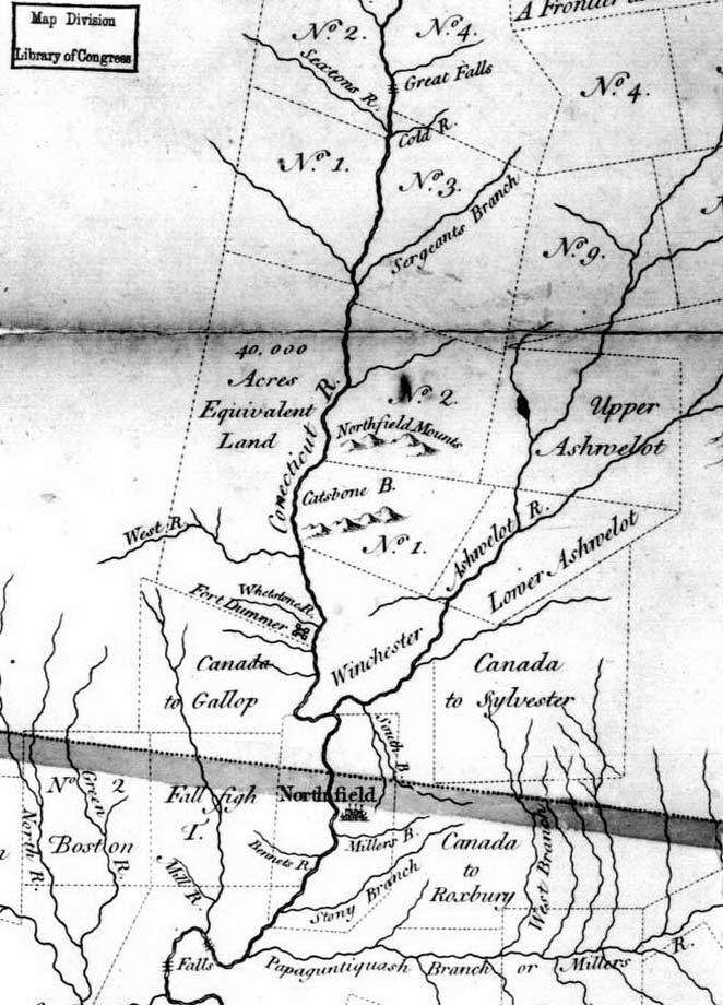 Unmapped wilderness lay to the north and west of Fort Dummer as shown on our first map. Map 1 is an excerpt from a much larger map of Massachusetts and New Hampshire by William Douglass. A detail of the Brattleboro area is shown on this page, with the town of Brattleboro lying within the “Equivalent Land”*, a large tract of land at the edge of the western frontier.The towns depicted here were all established by Massachusetts, which claimed all the land shown on this part of the map. The oldest town on the detail map is Northfield, which then included Vernon, Vermont and Hinsdale, New Hampshire. Northfield was established in 1672, and was the northernmost settlement until the early 1700s.
The heavy shaded line is the New Hampshire / Massachusetts line, which was set by the English King in 1741. There was no Vermont in the early years. The town called Canada to Gallop is now Guilford, Fall Fight Town is Bernardston, Mass., Chesterfield is township “No. 1” (east side of the river), next to ‘Lower & Upper Ashuelot” (Swanzey & Keene, New Hampshire). It is interesting that this very old map shows the two principal waterways in Brattleboro by their present names, the West River and Whetstone River (Brook).
To protect the pioneers in the Connecticut River Valley, the Province of Massachusetts decided that a fort should be established upriver from Northfield.
2. The Equivalent Lands and Fort Dummer
The “Equivalent Lands” covered most of today’s Putney, Dummerston and Brattleboro – about 44,000 acres. 
That unusual title came about as the result of a Provincial boundary adjustment. When the Massachusetts / Connecticut boundary was settled in the early 1700s, Connecticut lost some land, and Massachusetts agreed to compensate Connecticut by giving that Province some land as an equivalent for lands lost.
The “equivalents”, which included two other tracts beside this one, were sold by Connecticut to raise money for Yale College, and the buyers in turn sold this 44,000 acre tract to four men including William Brattle.
The Equivalent Lands were never mapped as far as we know, but there is a written description in the Connecticut Archives.
The description records a twelve mile long tract of land starting “…at the northward end of the Great Meadow …“ (Putney) and then proceeding downstream to “…the mouth of the brook that emptieth itself unto Connecticut river at the lower end of the Meadow, about three miles southward of the West river…”
The description then follows general bearings to the west, north and east as shown on the sketch map which we have prepared for this publication. The brook three miles below the West River is the stream we now call Broad Brook.
======================================================================================================================================
The map below, from Mary Cabot’s “Annals of Brattleboro”, depicts the area of the southern boundary of the Equivalent Lands.

The horizontal line is the south line of Brattleboro, meeting the Connecticut River at Venters Brook.
The diagonal line is the south line of the Equivalent Lands, which meets the Connnecticut at Broad Brook. This line was also the north line of “Gallups Canada” as Guilford used to be called. This unusually named town was created by Massachusetts in 1736 as a land grant to soldiers (Gallup and others) who went to Canada on an earlier military expedition.
The vertical line to the right of the quarry (lower right) is the present Guilford/Vernon town line. The map also shows two early private land grants in Vernon (which was then part of Northfield) along the river.
It is not known whether any Europeans lived in this area in the 1720s and 1730s, other than soldiers at Fort Dummer. The villages shown on this map are those of the 1920s when Cabot’s history was published.
======================================================================================================================================
The relative safety brought on by Fort Dummer encouraged more settlement, and in 1733 and 1734 the towns of Winchester, Swanzey and Keene were established along the desirable Ashuelot River in today’s New Hampshire (see Map 1).
 The early pioneers chose the best land first – it would be a few more years until the Vermont lands would be claimed for townships. Winchester (then called Arlington) had an inverted “L” shape which gave it access to both the Connecticut and Ashulelot Rivers.*
On the Winchester charter map, from the Massachusetts Archives, we see Fort Dummer, here labelled the “Truck House”. To “truck” was to trade.
Fort Dummer was a center of commercial activity as well as a fort. More details on Fort Dummer follow on the next page.
This old map also shows the two large islands which existed until the mid 20th century, at the site of the modern bridge between Hinsdale and Brattleboro.
Other maps of these islands are on page 19.
======================================================================================================================================
 As noted earlier, the English King (George II) decided that the Massachusetts / New Hampshire boundary was to be an east-west line.
However, no one, including the King, knew where the line was on the ground.
Surveyor Richard Hazzen was sent out into the wilderness to actually survey the line in the winter of 1740-1741. Hazzen’s map shows all prominent features he and his survey crew found along the way, including Fort Dummer.
It is not clear whether Hazzen went to the fort. He spent the night at Northfield, the substantial settlement depicted here below the fort.
In his diary for April 6th, 1741, he reports that he crossed the Connecticut “with great difficulty…in a canoe…” and ascended a high hill from which he had “a fair view of Fort Dummer…”
======================================================================================================================================
Map 5 Fort Dummer
The fort was built in the winter of 1724 on a tight schedule.
 Open hostilities with the Indians (sometimes called “Father Rasle’s War”) had begun the summer before, including an attack on Northfield.
The Massachusetts legislature voted on December 27, 1723 “…to build a Block House above Northfield in the most convenient place on the lands called the Equivalent Lands… .“ A few weeks later Colonel John Stoddard, the regional commander, wrote a letter with his specifications for the fort, including this drawing (Map 5). Stoddard’s plan for Fort Dummer shows a square building with four “Mounts” – raised towers from which soldiers could see the approaching enemy.
Stoddard specified that the fort “…be made of hewed timber…” and “…the Timber to be bullet-proof…” About twenty men built the fort that winter, under the command of Timothy Dwight of Northampton. Stoddard’s letter is in the Dwight family papers at Yale University’s Beinecke Library. Why would a Brattleboro historical document be at Yale? Brattleboro’s pioneer soldier was the grandfather of an early President of Yale, also named Timothy Dwight.
======================================================================================================================================

Within the first year there was a conflict. Three or four men are supposed to have been killed on October 11 of 1724 when about 70 Indians attacked the fort. That was the only known fight at Fort Dummer itself. For the next few years the fort was used as an outpost for scouting parties.
The location opposite Wantastiquet Mountain was well chosen.* One old letter reports that scouts were “…sent up ye West River Mountain to lodge on ye top and view Evening and Morning for smoak…”
A period of peace began in the late 1720s, and the military garrison became a base for trade with the Indians. In June of 1728, Massachusetts appropriated a large sum of money for goods “…to be lodged at the Truck-house above Northfield to supply the Indians withal.” Some soldiers had their families with them, notably Captain Timothy Dwight, whose wife, Experience King Dwight, gave birth to a child at Fort Dummer in May of 1726. This child, also Timothy, became the father of the future Yale president, and is supposed to have been the first English child born in Vermont.
Published histories are not clear on the matter, but it appears that several other familes, including children, lived at the fort during this early period. For 10-15 years there seems to have been relative peace near the fort, in fact a peace treaty was agreed to at the fort in 1736 between some of the Indians and the Province of Massachusetts.
======================================================================================================================================

By the mid 1740s there were more settlers in the area. The Ashuelot Valley towns such as Keene and Winchester each had a few families, as did Putney and Westminster along the Connecticut. This decade was difficult for Fort Dummer and for the nearby settlers.
War broke out in 1744 betwen France and England and conflicts soon spread to the Brattleboro area. From that time until the end of the decade there were numerous armed skirmishes, several resulting in deaths. The fort was not attacked, but soldiers from Fort Dummer died on scouting missions, as did settlers in nearby towns. It was so dangerous that most of the nearby settlements were abandoned for a few years.
During this period before Vermont was established, the “Equivalent Lands” and Fort Dummer were in New Hampshire, but maintenance costs and staffing were paid by Massachusetts.
The Province of New Hampshire – whose nearest population centers were many miles to the east over difficult routes – did not feel it should pay for a fort which protected mostly Massachussetts people in the Connecticut River valley. However, King George finally ordered New Hampshire to pay for upkeep and in 1749 New Hampshire sent surveyors out to make a map and gather some other facts about the fort.
======================================================================================================================================
A copy of the original 1749 map is reproduced here, along with a circa 1891 tracing which is a bit easier to read, and which shows the fort’s relationship with the river. This is the only known map of the fort as it was built.*
In addition to this map, the surveyors provided a written description of some of the fort’s construction details. Those notes are included on the CDROM version of this book.
The site of the fort, now under water, is presumed to have been eroded away. In 1976, during a temporary lowering of the river for dam repairs, a limited archeological dig was conducted on the site. The dig resulted in a number of artifacts and the confirmation that most of the fort site was probably lost to history.
3. The 1753 Charter and the First Settlers
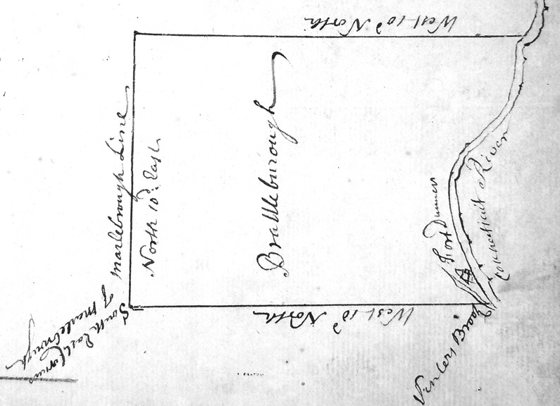 Two hundred and fifty years ago, in 1753, the town of Brattleboro was chartered by the Province of New Hampshire.
Our next map is a copy of the original map from the charter preserved at the New Hampshire Archives. The charter itself is reprinted on page 70 at the end of this book*.
In two respects this is the original map of Brattleboro: the New Hampshire charter both created the present boundaries and gave the town its name.
The grantees- the first landowners – were required to put some effort into their new land – cultivating land, building a church, etc. The grantees, it was assumed, would either settle on this land themselves, or would sell tracts to others who would in turn make the required improvements.
At this time this territory is still part of New Hampshire, though most of the residents – those living in Fort Dummer – are soldiers on the Massachusetts payroll.
The map shows Fort Dummer on the Connecticut River a short distance above Venters Brook.
======================================================================================================================================
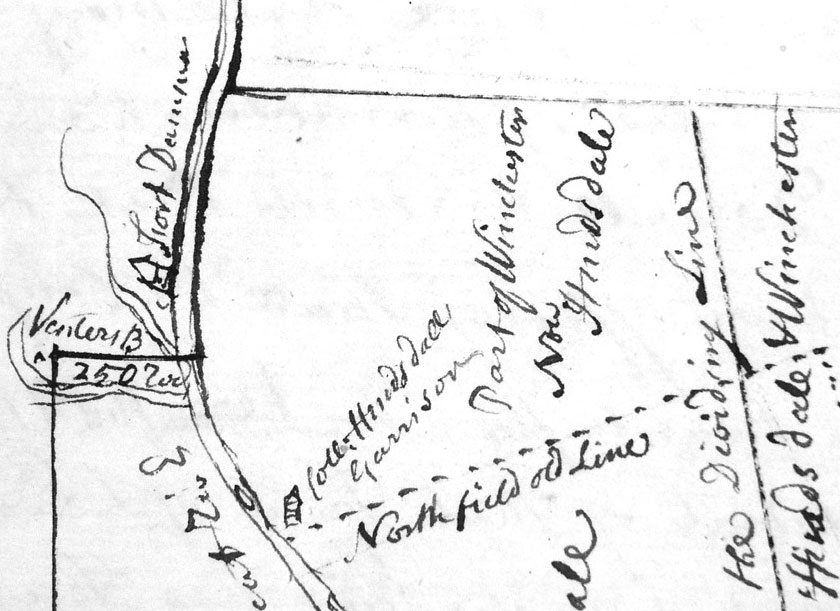 The second map on this page shows the adjoining town of Hinsdale (then including Vernon) where there was second fort – Hinsdale’s Garrison – across the river. Venters Brook and Broad Brook (not labelled) are shown.
This map is part of the Hinsdale charter map, also made in 1753, and was probably drawn by the same person who drew the Brattleboro map.
The Hinsdale fort was a reinforced house, not as substantial as Fort Dummer. There were other fortified houses on the Brattleboro side of the river, known as Bridgeman’s and Sartwell’s Forts.
When the Brattleboro charter was issued, there was relative peace on the frontier, but it would not last. War broke out again between France and England in 1756, and the Brattleboro area became very unsafe. An early settler, Benjamin Moor, who had a rude cabin on present Route 30 near the Retreat farm, was killed by Indians in 1758. His wife and children were taken as captives to Canada. Settlers in Putney, Westmoreland and Keene were killed in this same year. The danger limited settlement, and the Brattleboro grantees failed to make the required improvements under the 1753 Charter. They asked for and received a second charter – an extension – in 1761.
======================================================================================================================================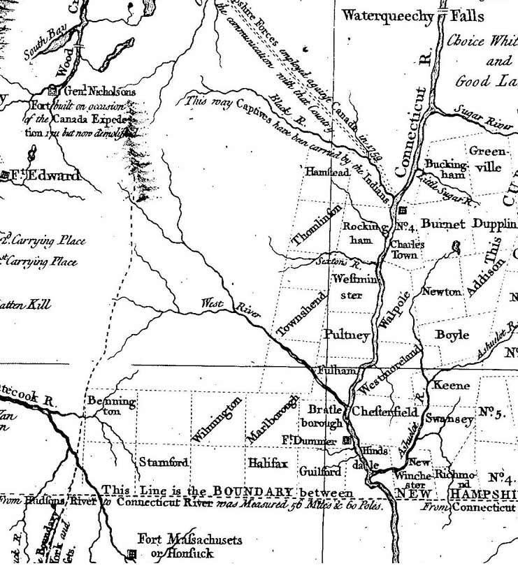
The next map shows the situation on the northwest frontier about 1760. This is an excerpt from an important early map, the Blanchard & Langdon map of New Hampshire.
The map was printed at the behest of the Provincial governor and shows the New Hampshire townships recently created. Most of what is now Vermont is uncharted territory except for Brattleboro and a few other towns along the Massachusetts border and the Connecticut River. On the west bank of the river are the new towns of Brattleborough, Guilford, Fulham (Dummerston), Putney, Westminster and Rockingham. These towns were all chartered by New Hampshire in 1753.
On the east side of the river, charters and new names were given to towns which were now to be called Chesterfield, Swanzey and Keene – also about 1753. The towns on the west side of the river soon came to be known as the “New Hampshire Grants”. This flurry of activity by New Hampshire was related to a dispute with the Province of New York, which held a competing claim to the lands on the west bank of the Connecticut River. The dashed line on the left side of the map, a projection northward of the New York / Massachusetts boundary, was the western limit of New Hampshire as claimed by Governor Wentworth.
There was still no Vermont.
At this time there were a few settlers in towns along the river. Brattleboro’s residents were mostly the soldiers at Fort Dummer, some of whom had families. A few settlers had started homesteads in the towns above Fort Dummer which had better farm land.
Westmoreland, Walpole, Putney, and Westminster each had perhaps a half-dozen familes in the mid 1750s. Most of these farms were abandoned by the end of the decade due to the danger. Note the route labelled “this way Captives have been carried by the Indians”. Many of the Indian attacks in this period were by Indians from French Canada. The French authorities frequently paid ransoms to the Indians for English hostages, who would then be exchanged for French prisoners held by British forces.
Peace came to this area permanently in 1760, when the French city of Montreal was captured by English forces. Settlers moved into Brattleboro and the surrounding towns in large numbers almost immediately after the fall of Montreal.
As noted earlier, Brattleboro’s charter was renewed in 1761, with its requirement that the lands be improved. A year later, John Arms and Samuel Wells began their homesteads. John Arms settled on present-day Route 30 near the Brattleboro Retreat, where he soon built the first tavern in Brattleboro. Samuel Wells built on a site nearby along the same road. Samuel Wells was the most eminent of Brattleboro’s early citizens; he was the lead grantee under the New York grants and became the first judge in Brattleboro.
Meanwhile, the New Hampshire / New York dispute boundary dispute was coming to its climax. In 1764, King George III ruled in favor of New York and made the Connecticut River’s west bank the new Province boundary.
An interesting footnote to history is that the King was 26 years old when he made this decision which determined today’s Vermont / New Hampshire boundary line. The King’s ruling was not very precise however, and the boundary was in dispute in the 20th century. A United States Supreme Court decision in 1936 was necessary to make certain this ancient boundary.
4. Early Land Divisions The New York Period
After the King ruled in 1764 that Brattleboro and the rest of New Hampshire Grants were to be part of New York Province, land titles were clouded. To make more certain their land rights, the landowners asked the Governor of New York to give them a new title to Brattleboro. Their 1765 petition stated that “…there is a tract of land Now Lying in Said Province of New York by ye Name of Brattleborough…”
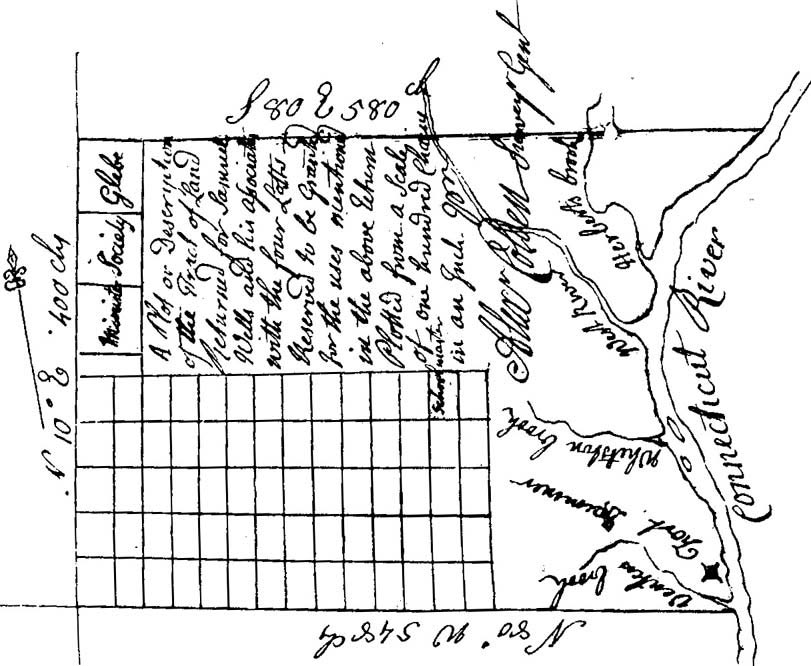 A year later, this survey plan of Brattleboro was issued by Alexander Colden, the Surveyor General of the Province of New York. Colden’s map was accompanied by text whch stated “I Have Surveyed and laid out by Samuel Taylor for Samuel Wells and twenty other persons…land..in the County of Cumberland within the Province of New York…known by the name of Brattleborough”. Colden is telling us that he measured and divided this land for the twenty one men who owned it all under the prior New Hampshire land grant. (Samuel Taylor – the first name mentioned – may have been the actual land surveyor, as Colden probably did not visit Brattleboro).
This map is more precise than the 1753 New Hampshire Charter map. Here we have both compass bearings and distances, and the text states that the total area is 19,500 acres.
Most noticeable, this map sub-divides a large part of Brattleboro. The large rectangular grid in the southwest quadrant consists of 5,400 acres divided into 70 lots. It is not clear whether this is the original subdivision of that 5,400 acre tract, for a later map, the Wheeler map on page 14, indicates that there may have been a prior New Hampshire subdivision.
Unfortunately, Brattleboro’s early land records are missing. The map also depicts three 350 acre lots in the northwest corner reserved for religious purposes and a 100 acre school lot. These latter parcels were not the property of Wells and his associates. They were set aside by the Province to encourage the establishment of the local church and school.
======================================================================================================================================
Map 13 Border Towns ca 1770
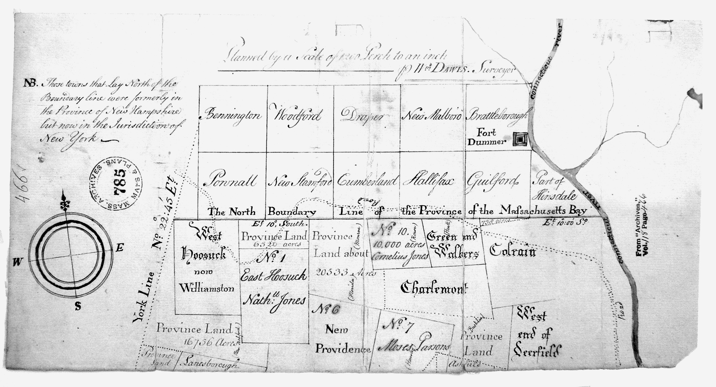
This next map, undated, appears to depict conditions circa 1770. The map was found at the Massachusetts Archives, which suggests that it may have been drawn to help that Province deal with the problems caused by the new colonial boundary. A note in the left margin of the map states that the towns north of the line were previously in New Hampshire but are now in the jurisdiction of New York.
Note that Vernon is called “Part of Hinsdale”. That is because the Town of Hinsdale was on both banks of the river before the river was made the boundary, and was thus left in an odd situation. The King’s boundary decision divided that town in two, but did not specify that there should be two separate towns. For a while after the 1764 edict, the citizens of Hinsdale still lived in one town, but those on the east bank were residents of New Hampshire and those on the west bank were in New York.
A prominent feature of this map is Fort Dummer, shown as a large square symbol. No other forts or structural improvements are shown, indicating the significance of Fort Dummer in the late colonial period of American history.
The town lines shown here in Vermont (then New York) are approximate, and some names are quite different than modern names. The Town of Draper, for example, is now Wilmington, and Cumberland is Whitingham.
======================================================================================================================================
Map 14 1779 Sauthier
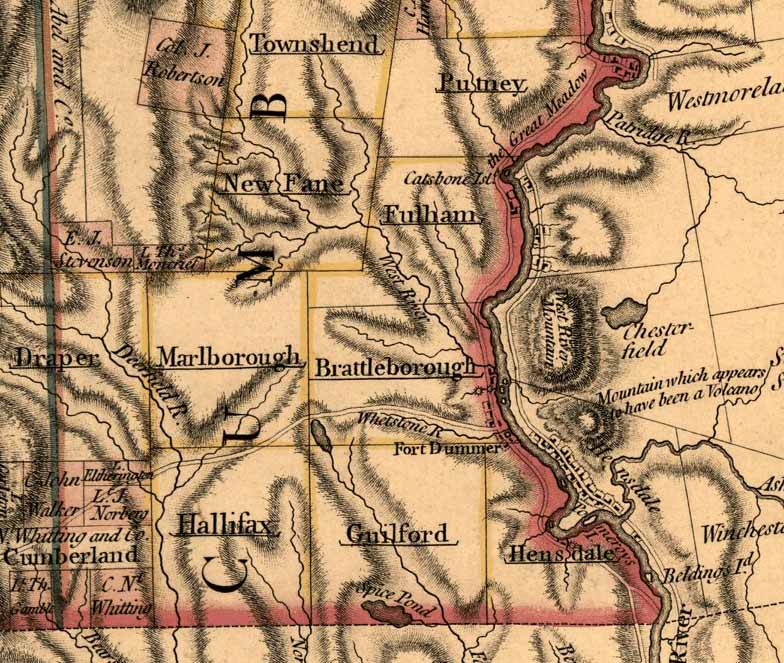
The Brattleboro area appeared on a map of “The Province of New York” in 1779, made by Claude Joseph Sauthier at the direction of the New York’s Governor Tryon.
When this map was published there was widespread ferment, as many of the residents were in rebellion against the notion that they had to be part of New York.
This section of the map is notable for its display of some natural turbulence – the “Mountain which appears to have been a Volcano”. – Wantastiquet Mountain. There are some other historical records indicating that gases or sounds may have come from the mountain, but no scientific evidence exists to support the notion that a volcano was there.
The Sauthier map also shows what may be an old military road, leading from Fort Dummer westerly towards Fort Massachusetts (see Map 11).
======================================================================================================================================
Map 15 Cabot Map
Our next map is a more detailed depiction of the earliest land grants. It covers the same area shown on the 1766 New York map, and adds more information. (The color original is easier to read and available on the CDROM edition). It is not an original map, in the sense that it was not made at the same time as the conditions it depicts. It is a reconstruction of prior conditions, made by an amateur historian in the late 1800s.
This very useful document of Brattleboro’s history was first printed in Cabot’s “Annals.” Cabot credits Judge Hoyt Wheeler for making this map, but does not explain much about the map. Wheeler would have used old deeds, plans and other documents to compile this map which depicts both New Hampshire and New York land grants in the 5,400 acre area.
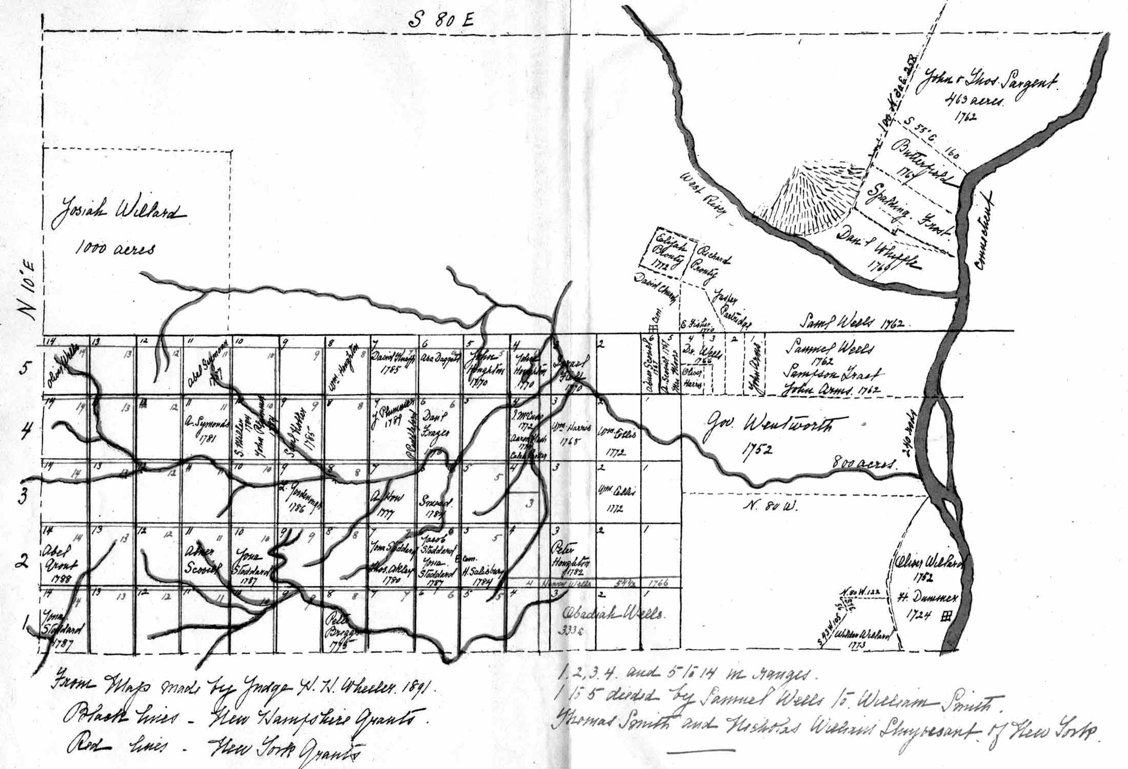
It is not clear where he got the New Hampshire land grant information, as there are no known original maps of this subdivision. On this map the New Hampshire lots are numbered 1-14, and the New York lots, slightly smaller, are numbered 4-14.Wheeler also shows some of the oldest land grants around Fort Dummer in the southeast corner of town, and further north along the Connecticut River. No roads are shown, but all major streams are depicted.
Two of the lots shown here are taken from the 1753 Charter. Downtown Brattleboro is within the 800 acres shown as “Gov Wentworth”, the tract reserved for the colonial governor of New Hampshire. The “Oliver Willard 1752” tract in the lower right corner is the 200 acres specifically described in the Charter – the only private tract defined in that document. The charter excepts that 200 acre tract “…as the same is now fenced and improved….” from the rest of the Brattleboro grant because Willard had “…heretofore cleared and improved the said Tract….”.
This tells us that Oliver Willard, who was one of the soldiers at Fort Dummer and one of the twenty-one grantees of Brattleboro, may have been the first “settler” in Brattleboro, in the sense that he was growing crops and had livestock.
It is not known why Wheeler dated these lots 1752 when the charter was written a year later. Sketches of the Charter’s land descriptions are printed with the Charter on page 70.
The original town center was on Meetinghouse Hill along Orchard Street. On this map it is in the area of the small cemetery symbol at the northeast corner of the 5,400 acre grid. The cemetery is just above a long horizontal line, sometimes refered to as “the center line of the town” in old documents.
======================================================================================================================================
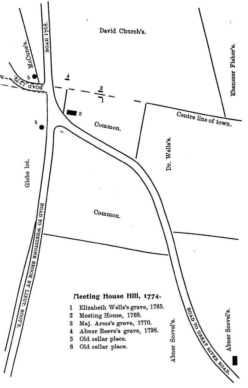
The town center was depicted in more detail on another latter-day map, taken from a pamphlet authored by Reverend Lewis Grout in 1894. Grout was an historian who researched and wrote about Brattleboro’s early history.
Today it is the site of Meetinghouse Hill Cemetery. The meetinghouse was a sort of church and town hall in the 1700s. Here religious services were held regularly, and public affairs were attended to at town meetings.
The diagonal road on the right side of the map is Orchard Street, which currently (2003) extends straight through what is shown here as the Common, slightly to the right of the Major Arm’s grave site (item 3). The three other roads no longer exist.
Note the “Centre line of town” line, which corresponds with the long horizontal line on the Wheeler map. This line runs through the middle of Meetinghouse Hill Cemetery. For more information on old lot lines in Brattleboro, refer to the modern map on page 74.
======================================================================================================================================
Map 16 from Holland Map of New Hampshire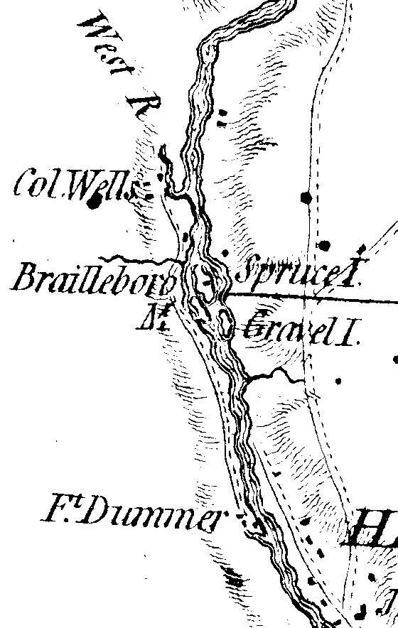 The small inset map on this page is part of a large New Hampshire map published in 1784, but based on surveys done about 1774 under the direction of Surveyor-General Samuel Holland. The “Holland” map indicates the importance of Colonel Samuel Wells (the only name shown) and names the two islands, perhaps for the first time on a map.
The upstream island, Spruce Island, must have been higher in elevation than Gravel Island, since trees were growing on it. It is interesting also that Fort Dummer is shown, as the fort is supposed to have been abandoned in the early 1760s.
Note that the road in Hinsdale stops south of the islands, at a location a little bit north of Fort Dummer. This suggests that early river crossings were made near Fort Dummer and not at the islands. They certainly were in the late 1700s, as in 1786 a ferry license was issued to a James Hubbard. Hubbard’s application described the ferry site as “…the place where Fort Dummer formerly stood…”
The road shown here from Fort Dummer to Colonel Well’s house on the West River may be the oldest road in Brattleboro.
5. Early Roads and Villages
Map 18 1796 Brattleboro’s First Road Map – from the Whitelaw Map of Vermont
The earliest maps of Brattleboro, seen in the previous pages, showed no roads although some were built in the late 1700s. A 1796 state map, the noted Whitelaw Map of Vermont, may be the earliest “road” map of Brattleboro. Here we see six major roads in Brattleboro, and two population centers.
 In the center of the map is the town meeting house in West Brattleboro. The old town center on Meetinghouse Hill was abandoned when this new meeting house was built in 1785. It stood on Western Avenue very close to the present site of the First Congregational Church. True to the New England tradition, the meetinghouse was near the geographical center of town, so that no one had to travel too far for religious services or to attend to town affairs.
To the west, on Ames Hill Road, labelled “Nashs”, is the mill of Aaron Nash, built about 1770. To the right, at the outlet of Whetstone Brook is the small mill village which later developed into downtown Brattleboro. Samuel Dickinson had a sawmill here near the outlet of Whetstone Brook. This mill was probably on the same site as the grist mill supposed to have built here in 1762.
Further north is the location of the Arms Tavern, though this map seems to show it incorrectly on today’s Putney Road. The Arms tavern actually stood on Route 30, on the west side of the West River, at the site of the farm buildings known as the Retreat Farm.
Above “Nashs” we see the home and mill of Seth Smith, a notable early citizen. Smith was a prominent “Yorker” in the 1770s, a supporter of New York’s status quo authority when upstarts like the Green Mountain Boys wanted separation from New York. Smith’s house was built in 1768 and still stands today. It is interesting that Whitelaw’s map shows Smith’s mill site, but no road leading to it, perhaps an indication that no good road yet led to that location.
======================================================================================================================================
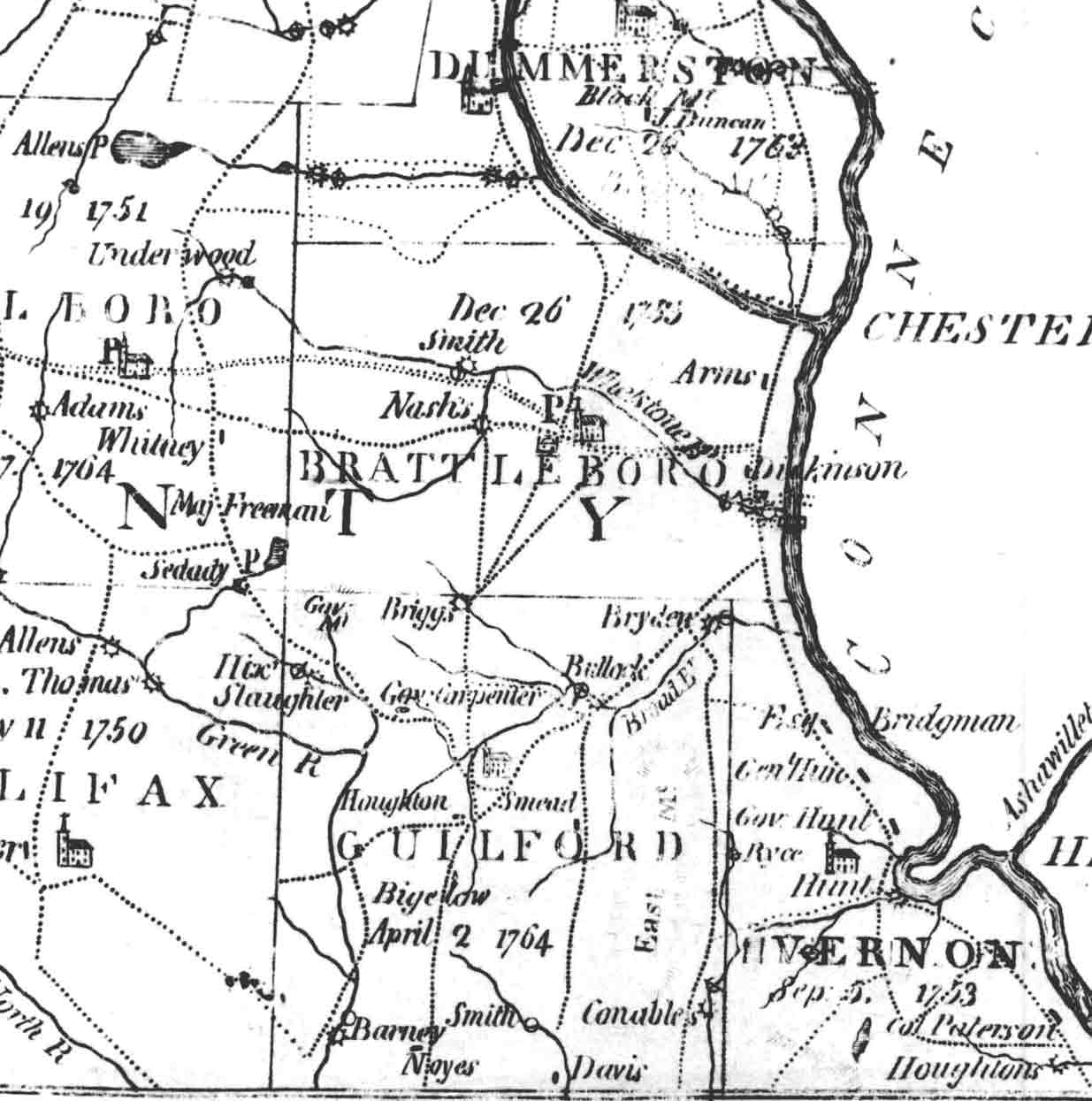 Map 19 1810 Brattleboro in 1810 – from the Second Whitelaw Map of Vermont
The Whitelaw map was reissued 14 years later, in 1810. This excerpt is chosen to show Brattleboro and the surrounding towns. A similar view in 1821 is re-printed in color on the back cover of this book. The Whitelaw maps (there are several) provide a series of snapshots of the growth of Vermont. By 1810 Brattleboro had regular mail delivery as indicated by the “P” symbol near the Meetinghouse. A few new roads are shown, notably the Windham Turnpike (double lines) which extended from Brattleboro to Marlboro and towns to the west. 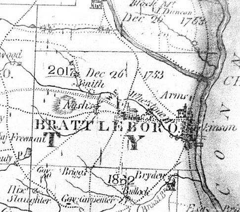
Map 20 1821 Brattleboro in 1821 – from the Third Whitelaw Map
The 1821 Whitelaw map (below and on back cover) is notable for its depiction of the enlarged downtown Brattleboro area and the Congregational Church on the Town Common. A few more roads are shown, such as Upper Dummerston Road (middle top) and Sunset Lake Road (top left).
======================================================================================================================================
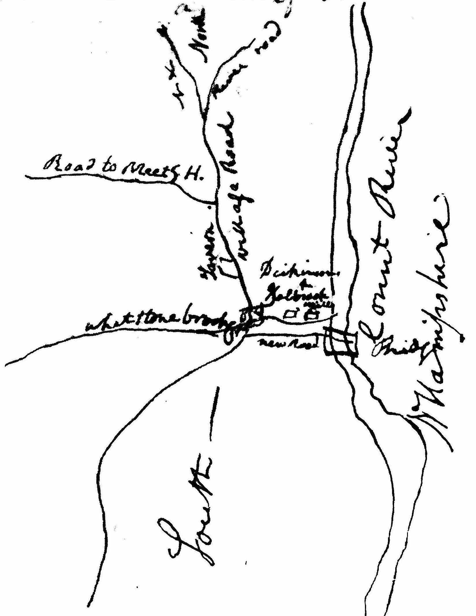 Map 21 1810 Samuel Elliott’s Sketch of Brattleboro.
He was informing Vermont’s Surveyor General that Bridge Street (“new road”) was now completed to the new bridge to Hinsdale.
The Surveyor-General’s records at the Vermont State Archives contain this hand-drawn map (Map 21), which is the earliest known map of downtown Brattleboro.
It is part of a letter written to James Whitelaw by Brattleboro’s Samuel Elliott. He sent the letter and map to Surveyor-General Whitelaw to help him with the new edition of the state map. Elliot’s letter reports that “…there is a new road in this village…to the new toll bridge…” over the Connecticut River.
The new road was Bridge Street, leading to the bridge across the river built in 1804. Elliot tells Whitelaw of the importance of this new street “…as it is connected with the Bridge and Turnpike in New Hampshire and Mass…” The turnpike – a privately built toll road – was a major improvement in Brattleboro’s access to the Boston area.
Turnpikes were designed as through roads with more direct routes than most local roadways, and they tended to be better maintained than town roads. Elliot’s letter mentions one other turnpike not shown on this map “…the new Turnpike from our Meeting House…has been made….” This refers to the Windham Turnpike which connected West Brattleboro to Marlboro and other towns to the west.
Other roads shown on this map are South Main Street bearing southeast, Main Street (“Village Road”), High Street (“Road to Meetg. H.”) and Linden Street and Putney Road (“River Road”). Two prominent businesses are shown: the Tavern on Main Street and the Dickinson & Holbrook Mills on Whetstone Brook. The Tavern was Samuel Dickinson’s tavern, built in 1795 on the site of the present Brooks House.
The “Holbrook” was Deacon John Holbrook, one of the giants of Brattleboro’s early years. Holbrook was a surveyor and printer who also had a warehouse at the site of today’s American building, and a wharf on the river near these mills. Not shown on this sketch map is the old road to the river, Arch Street.
======================================================================================================================================
Map 22 Proposed Canal
By the third decade of the new century Brattleboro was growing rapidly, as were the surrounding towns. The Connecticut River – the main “highway” of those days – was used for trade with distant cities. A canal built around the large waterfalls at Turners Falls, Massachusetts allowed freightboats to travel from Brattleboro to the sea. Another canal at Bellows Falls improved upriver commerce as well. Freight and passengers travelled on man-powered barges known as flatboats which were poled, paddled and sometimes pulled. Steamboats plied these waters as well, though they were not numerous. The travel upstream against the current was difficult in Brattleboro and at other locations, and plans were made to build a canal all the way to northern Vermont.
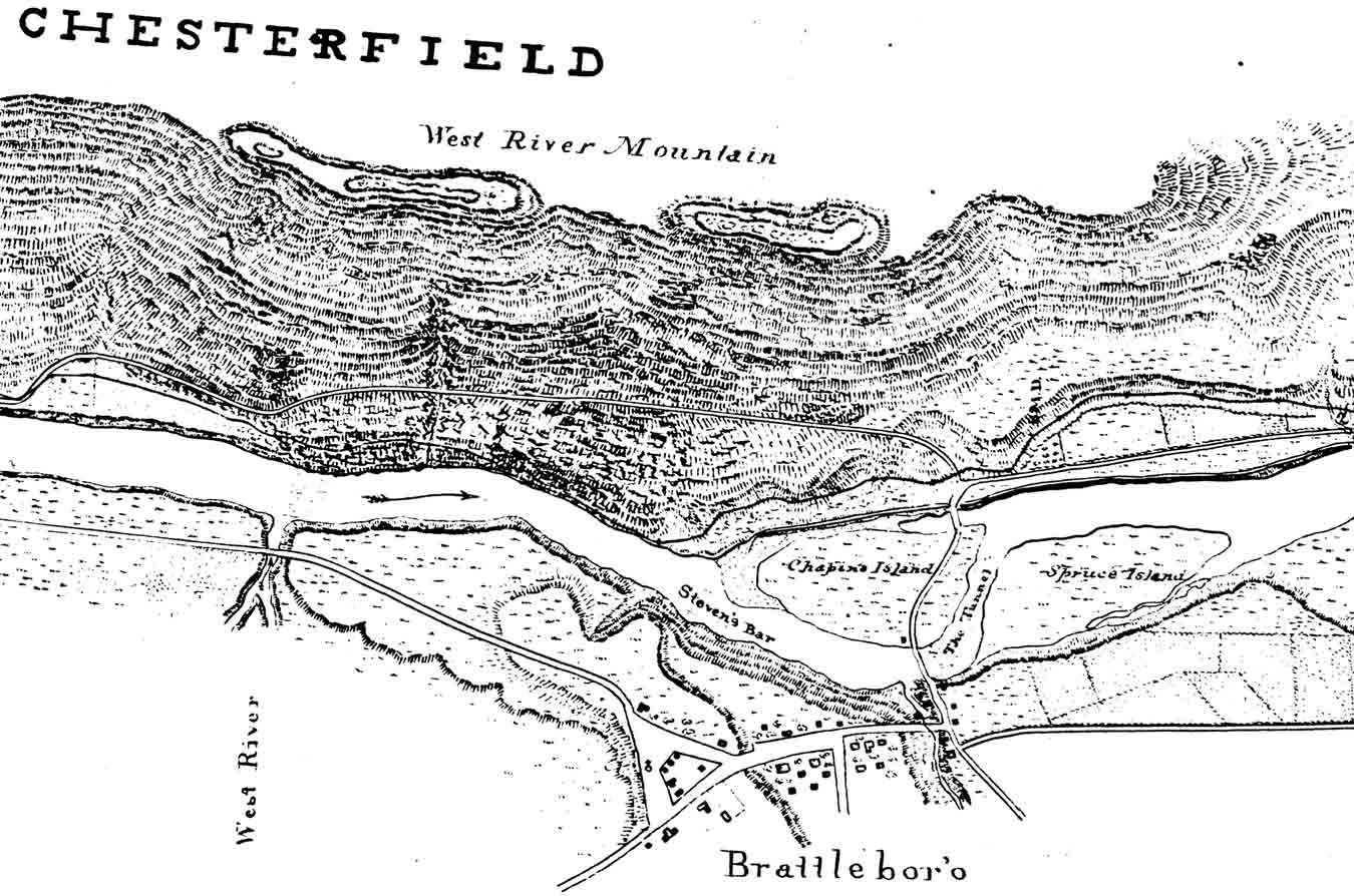 The large map is a detail from a multi-page map made by the United States Army Corps of Engineers in 1830, for the purpose of designing a canal route. North is to the left. The single dark line on the New Hampshire side of the river is the proposed canal route.
The map is useful to us because it depicts buildings in Brattleboro at an early time, and gives us some place names as well. Note that Wantastiquet Mountain has its old name, West River Mountain, and that the two large islands in the river are named. Chapin’s Island was named for Oliver Chapin, a prominent Brattleboro merchant. Chapin was a prime investor in the Brattleboro Bridge Company which built the bridge to Hinsdale, New Hampshire across the island. The bridge was a toll bridge for much of the 19th century.
The canal – which was never built – was to improve river commerce. Flat boats travelled to and from Brattleboro, but they could only travel at certain times of the year due such impediments as ice flows, low water, and fast water such as that shown between the islands on this map. “The Tunnel” was a narrow channel between the two islands through which the entire river was flowing when this map was made. The last few hundred feet of the water route to Brattleboro must have been very difficult in 1830. Note the shaded area on the far side of Chapin’s Island. That was probably an area of low ground which would flood during high water. That section of the river was sometimes called the “Little River”.
The several buildings shown on this map are the larger private houses and businesses in Brattleboro. At the north end of the Common we see the site of the old Centre Congregational Church.. The church stood on this site until 1842 when it was taken apart and rebuilt on the present site on Main Street. The map also shows the outlines of cultivation in the fields south of the village and on the Hinsdale side of the River.
======================================================================================================================================
Maps 23-27 The Bridge, the Islands and the Turnpike through Hinsdale, NH
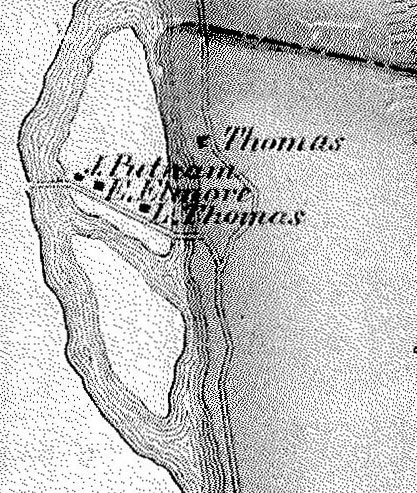
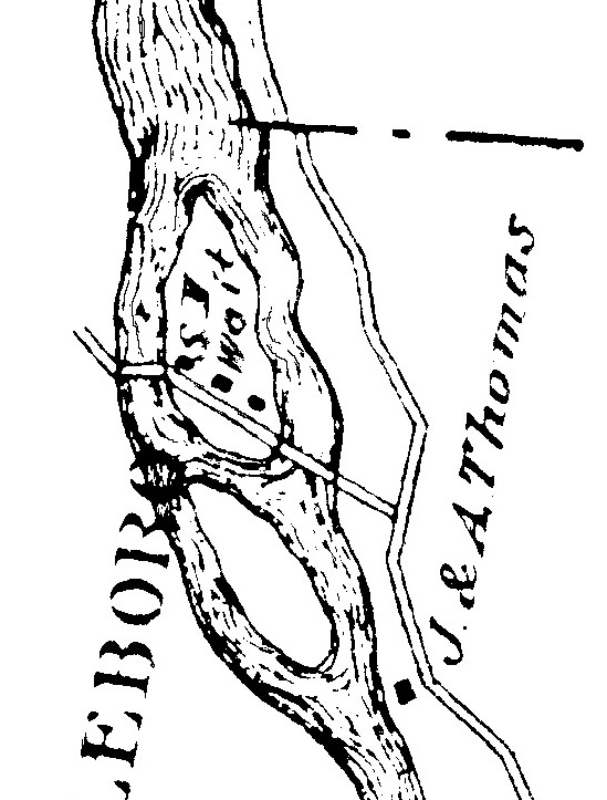
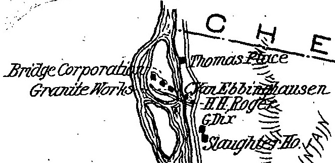
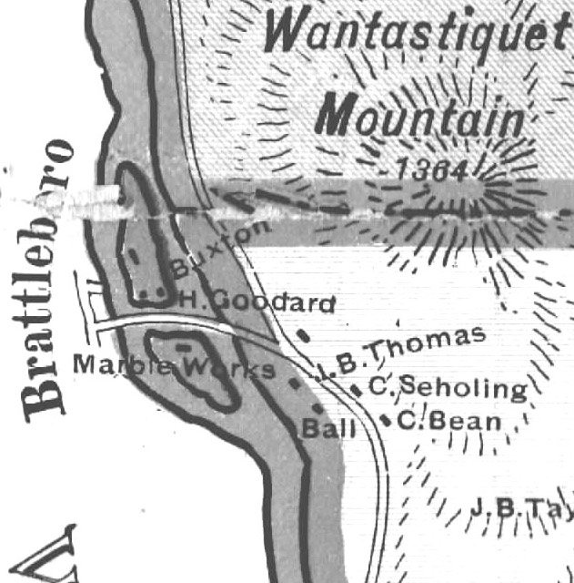
The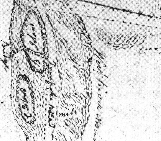 islands feature prominently in Brattleboro’s history, although they were actually in the state of New Hampshire, and don’t appear on all of the Brattleboro maps. The McClellan (1856) and Beers (1869) maps, for example, do not show landowner names on the islands. The five small maps are portions of maps of Hinsdale, New Hampshire which do show the islands. [1806 – 1858 – 1877 – 1892 – 1901]. The 1806 map is a manuscript map of Hinsdale from the New Hampshire Archives; the other four all from published Cheshire County maps and atlases. The top map, 1806, shows the newly built bridge (built in 1804) and a portion of the 6th New Hampshire Turnpike (now Route 119). The “5 miles” refers to a turnpike mile-marker at that spot. The mapmakers weren’t always careful: the 1906 map shows the bridge passing between the two islands as though it were a water passage.
======================================================================================================================================
Map 28 1849 (Wesselhoeft) Brattleboro and Vicinity
This next map, dated 1849, is an unusual document, both for its age and purpose. The original is a small map, about the same size as it is reprinted on the facing page. On this page is an enlarged section of downtown Brattleboro.
The map was issued inside a small booklet promoting the Wesselhoeft water cure business. In the mid to late 1800s Brattleboro became well known for two clinics which offered to cure a number of ailments with treatments including baths, massages, and exercise.
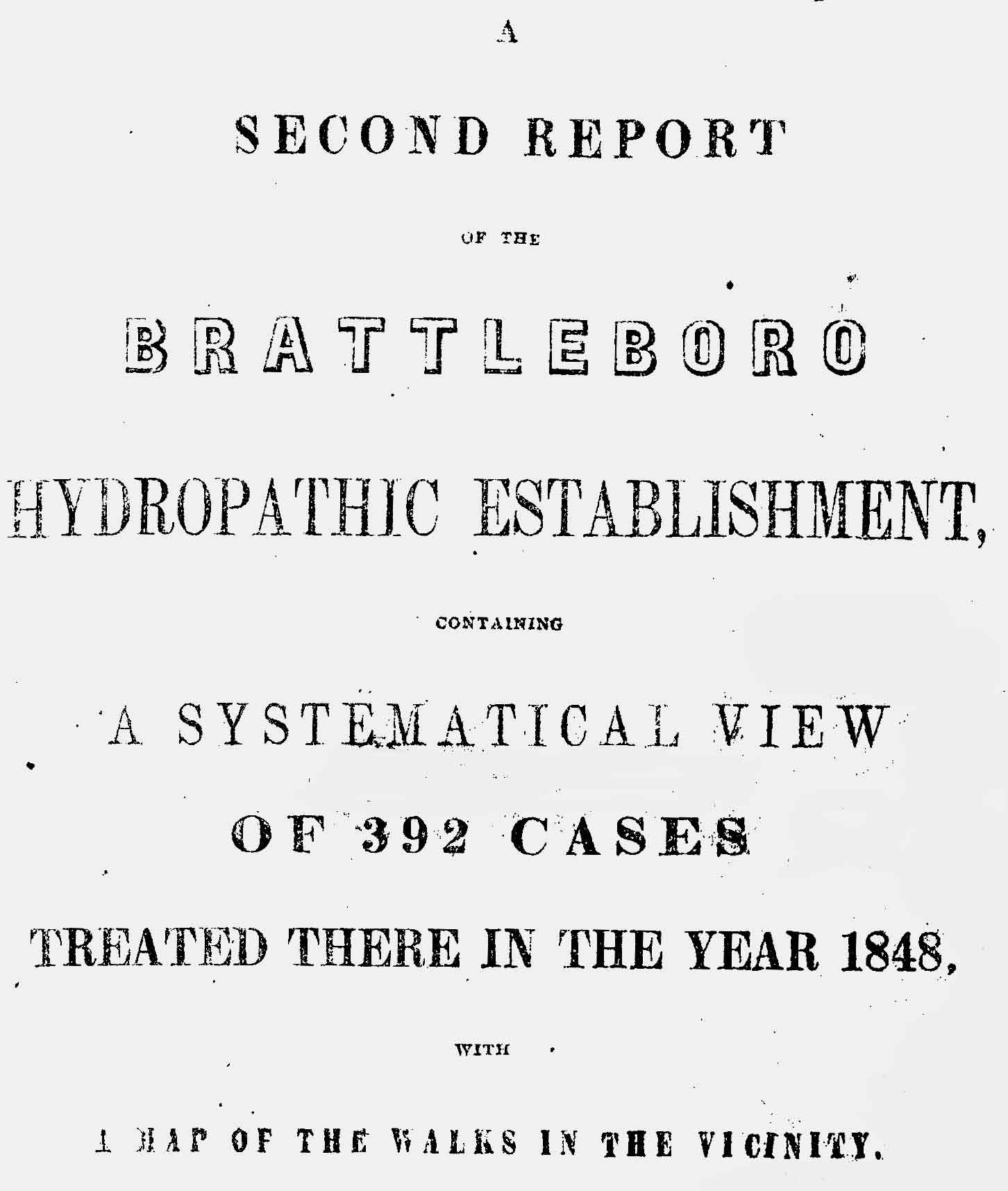
The “Brattleboro Hydropathic Establishment” opened in 1845, and three years later issued its “Second Report” describing its successes in treating 392 people in the previous year. The booklet was more of a sales device that a scholarly treatise. In addition to the enumeration of treatments, the booklet advocated the benefits of the fresh air, exercise and the pleasant environment of the Brattleboro area, and included this map “of the walks in the vicinity”. Readers are assured that “…the variety of scenery …is indeed remarkable…” and that this area was therefore “…peculiarly fitted for the purposes of the Water Cure..”
======================================================================================================================================
Map 28a Detail of Downtown Bratttleboro from Map 28
Here we see all the roads in downtown Brattleboro for the first time on a map.
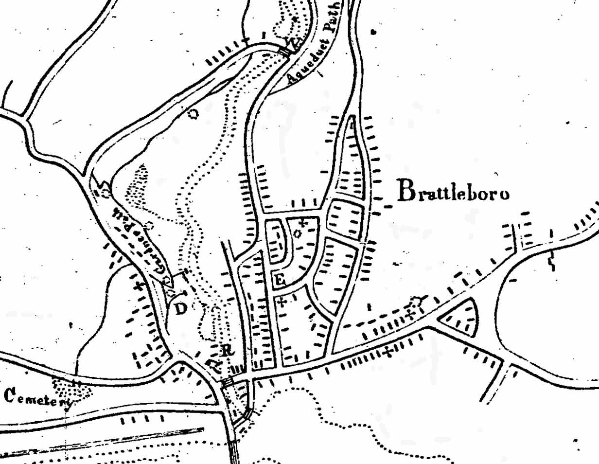 The enlarged detail shows the area from the Town Common south to the Prospect Hill Cemetery. The dashed lines are waterways; the heavy lines roads, and the small blocks are buildings.
On the right side, just below the bridge to Hinsdale, is the north end of the railroad (the darker double line), but no railroad station. The tracks from the south had been completed in late 1848, and a formal opening of the railroad (the Vermont & Massachusetts Railroad) took place on February 20, 1849. The railroad began regular operations in 1851.
The group of four houses shown just west of the rail line was known as the “The Patch”. In the 1840s Irish laborers lived in these buildings while they worked on the railroad.
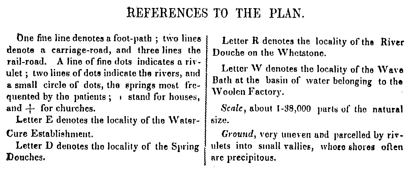
Our map shows all five of Brattleboro’s churches (as small crosses): the Methodist Church on School Street, the Baptist Church on Church Street, the Unitarian and Centre Congregational Churches on Main Street, and the Universalist Church on Canal Street. All these churches and many other features are seen more clearly on the 1852 Presdee & Edwards map which follows on page 24. The large letters refer to sites of interest to the patients of the Wesselhoeft water cure facility, which was located at the “E”, at the corner of Church and Elliot Streets. It is presently the site of the fire station.
======================================================================================================================================

Two hiking trails are labelled along the valley of Whetstone Brook: the Gardner Path along Canal Street, and the Aqueduct Path which extended from the Union Street / Elliot Street area westwardly along the north bank of the brook above Williams Street, out to the Centreville area. There is an unnamed trail leading from Canal Street near the church symbol to Prospect Hill Cemetery on South Main Street. This trail seems to follow the general route of Washington Street.
The “Wesselhoeft” map extends beyond downtown Brattleboro to Guilford Center on the south, and Upper Dummerston road on the north.
At the northwest corner of the map (note that the map is oriented with west at the top) is the old Meetinghouse Hill Cemetery on Orchard Street. The top center of the map (west) shows the Western Avenue / Guilford Street intersection and the Centreville area. The bridge over Whetstone brook is the bridge now called the “Creamery” covered bridge.
6. Introduction to Land Ownership Maps and Bird’s Eye Views
Most readers will find great interest in this next series of maps and views – detailed maps which show the actual sites of houses and buildings – many with the owners’ names. There are four separate detailed maps of the “downtown” section of Brattleboro – 1852, 1856, 1869 and 1895 and three of the entire town and of West Brattleboro Village: 1856, 1869 and 1895. Brattleboro is fortunate to have five detailed “bird’s eye” views as well. Three are reprinted here. For the reader’s convenience, maps of the same area are grouped together – first, the “downtown” maps and the bird’s eye views. Due to the large size of the originals, some of these maps are cropped, and the largest maps are not completely reprinted here. *
======================================================================================================================================
 1852 Presdee & Edwards
The oldest is the 1852 Presdee and Edwards map. The original is a wall map, measuring about 2’ x 3’. The map is reprinted here on 6 pages, except for the decorative margins (the CD-ROM edition has the entire map). This map is of great historical value because it is the first map to show buildings and owner’s names in Brattleboro village. In some areas even property outlines are shown.
======================================================================================================================================
 1856 McClellan’s Map of Windham County
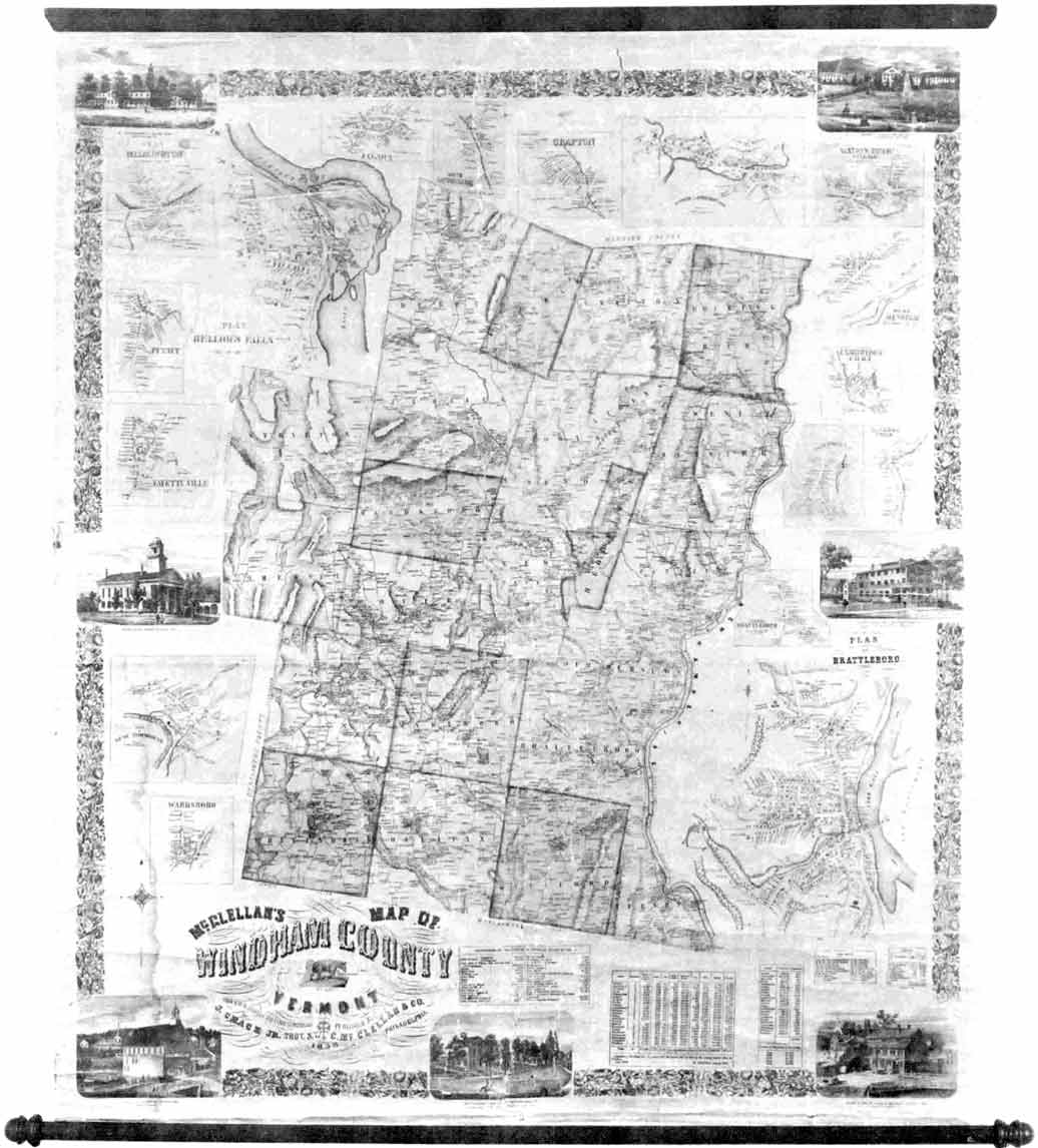
The 1856 maps of Brattleboro– one of downtown (page 30) and one of the whole town (page 55) – are from the large wall map entitled “McClellan’s Map of Windham County, Vermont”. The original map is about five feet square, and shows thousands of names in all of Windham County.
======================================================================================================================================
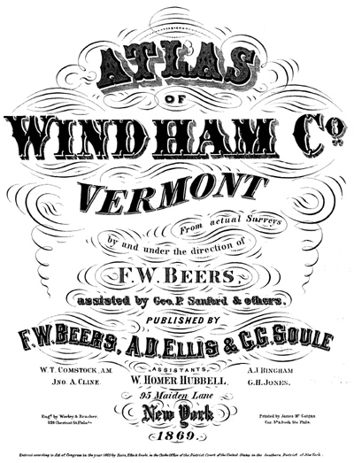
 1869 Atlas of Winham County by F.W. Beers
The 1852 and 1856 maps were published by commercial mapmakers from major American cities, unlike the earlier maps in this volume. This was a widely popular business in the mid 19th century, and we are fortunate that these businessmen found Brattleboro a fitting subject for their mapmakers craft. Wall maps proved a bit cumbersome however – they were large and expensive to print – and not so easy to use. So commercial mapmakers turned to atlases like the 1869 F.W. Beers Atlas of Windham County. This atlas provides four maps: a town map, and maps of downtown, West Brattleboro and Centreville.
======================================================================================================================================
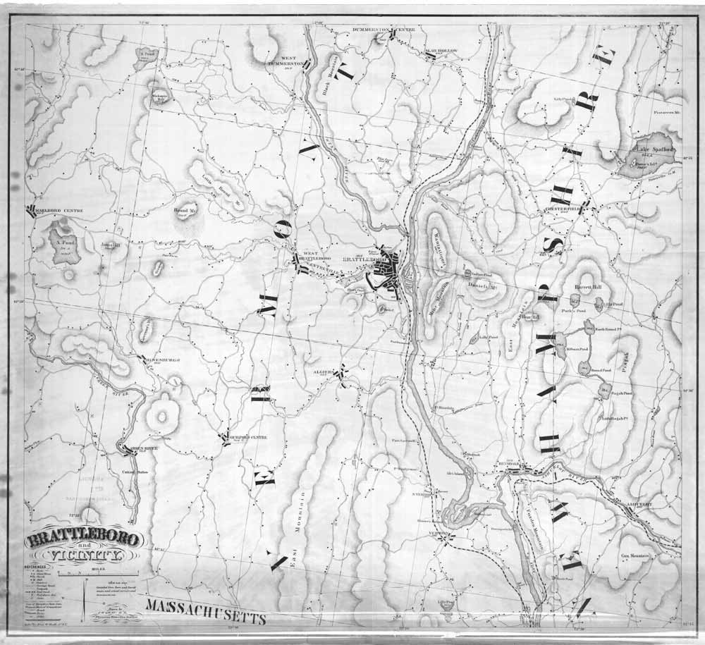 Circa 1860 Brattleboro & Vicinity by C.W. Grau
An unusual map of “Brattleboro and Vicinty” was produced about 1860 by Dr. Charles W. Grau, a physician associated with the Wesselhoeft establishment. Grau’s map showed all the roads, but not homeowners’ names, in Brattleboro and portions of each adjoining town. Grau died in 1861, but his map lived on – there are at least 3 versions. The original map measured 22” x 27”, and copies are extant at reduced size. A reduced copy was issued as a fold-out map in a small booklet, similar to a modern road map. One of the later versions is distinguished by the depiction of the West River Railroad which was built in 1880. The map showed interesting features like Chase’s Cascade, a small waterfall, and the nearby hiking trails on Wantastiquet Mountain.
======================================================================================================================================
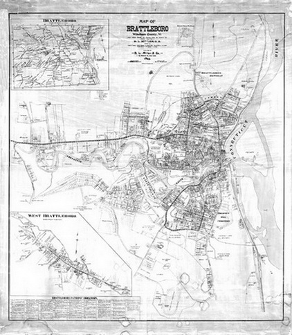 1895 Brattleboro by D.L, Miller
The D.L. Miller company of Philadelphia produced a large wall map, measuring about 4’ x 5’, in 1895. This is an extraordinarily detailed map of Brattleboro. The details include homeowner names, street addresses, property outlines, and the actual shapes of buildings. The entire town was mapped; most of the map is of downtown Brattleboro and West Brattleboro.
======================================================================================================================================
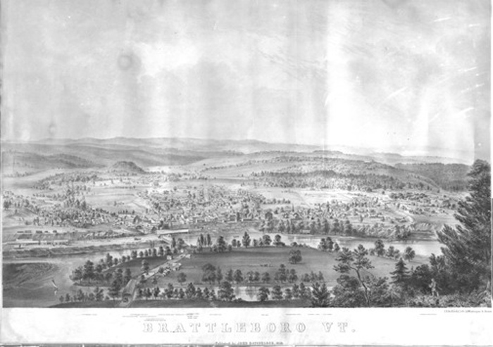 1856 Batchelder View of Brattleboro
Brattleboro was also the subject of several panoramic views published in the 1800s. These attractive lithographs were drawn as if the author were suspended in the air above Brattleboro – hence the common name “bird’s eye view”. In fact the artists almost certainly used Mt. Wantastiquet as their view point, although their technique did not require such a location. The first view is the 1856 print by John Batchelder. Views in the mid 1850s were relatively uncommon in the United States – only the larger cities and towns could support such an effort. Little is known about the author, but there are other examples of his work extant, including an 1863 bird’s eye view of the Gettysburg Battlefield. The publisher, J.H. Bufford of Boston, also issued a number of lithographs of US Navy ships during the Civil War.
======================================================================================================================================
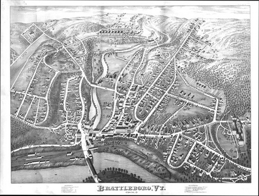 1876 Brattleboro by Bailey & Hazen
The next view was published by Howard H. Bailey and J.C. Hazen. This partnership was responsible for several other city views including Nashua and Manchester, New Hampshire in 1875 and 1876 and Holyoke, Massachusetts in 1877. Bailey’s brother Oakley is the author of the 1877 view of Greenfield, Massachusetts. Brattleboro was a convenient subject as these entrepreneurs passed through New England.
======================================================================================================================================
 1886 View by Lucien Burleigh
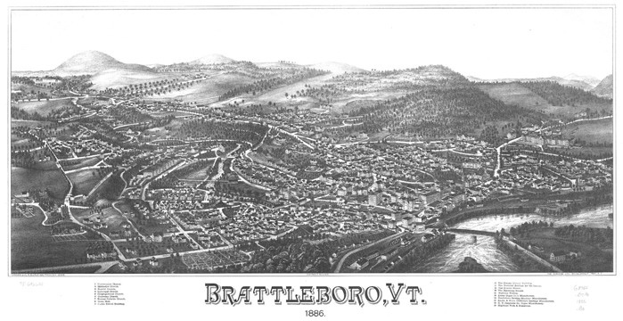
A decade later the last panoramic map of Brattleboro appeared – the Burleigh view. Lucien Burleigh was a prolific publisher of these lithographs. Shortly before this view appeared, he had completed his view of Hinsdale, New Hampshire, and in 1886 he also issued a view of Bellows Falls, Vermont.
======================================================================================================================================
7 Landowner Maps & Birds Eyes – Downtown 1852-1856
Map 29 1852 Presdee & Edwards
We begin with the maps of the developed, “downtown” section of Brattleboro and of West Brattleboro. The maps of the entire town follow beginning on page 54. Modern maps are provided on pages 74-75 to help with interpretation.The 1852 Presdee & Edwards map is the first accurate, detailed map we have of Brattleboro. Most of the map is printed here on three separate pages (omitted is the decorative border; the entire map is available on the CDROM edition).

Enlarged Detail of 1852 Map Main Street
Enlarged detail of Main Street, from Elliott Street to High Street. The railroad had just come to Brattleboro when this map was made. Hotels, such as the Revere House, were built to provide lodging for travelers. The Revere House was owned by James Fisk, whose son, also named James, moved to New York City, and became one of the noted “robber barons” of the nineteenth century.
======================================================================================================================================
 Enlarged Detail Whetstone Brook Mills
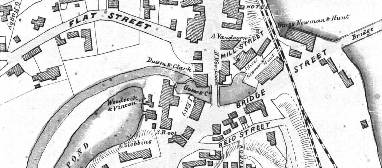
Enlarged detail of mill sites on Whetstone Brook. The pond was a mill pond providing water power for the Woodcock & Vinton Paper Mill, which operated at the site from 1847-1930. The mill pond is now a parking lot. The outlet of Whetstone Brook is not visible, as it passed beneath another water-powered mill complex, the Hines, Newman & Hunt Machine shop.
======================================================================================================================================
 Map 29 1852 Top section
While it only covers the central village, the Presdee & Edwards map does so with extraordinary detail. It shows landowner names, the outlines of their property, and even the shapes of the buildings. The first railroad, completed a year earlier, is seen coursing along the river. The largest building in Brattleboro was the Brattleboro Retreat, then known as the Asylum. The Retreat’s prominence is underscored by the fact that a pictorial view of the buildings was included in the top margin of the map. An interesting feature of this map is the list of Subscribers Names. The publishers sold copies of this map before publication and honored the subscribers by including their names and some occupations in the margins of the map.
Most of the street names are the same as those we have today, but a few are different. Keyes Lane in the upper right is now North Street. The undeveloped street just north of Keyes is now Bradley Avenue. It is interesting that the Bradley estate was contemplated for development in 1852 ( it is gridded into houselots), but that four decades later it was still undeveloped as the 1895 map shows us (page 43). The “R. Tyler” listed on several vacant lots is Charles Royall Tyler, son of the noted playright and Vermont Supreme Court Justice. His house is shown on Main Street next to the word “Main” on this map. The unnamed north-south street on the right side is now Tyler Street. The younger Tyler, who became a judge as well, later built a house for himself overlooking the river at the end of Terrace Street (the unnamed east-west street).
======================================================================================================================================
 Map 29 1852 Middle section
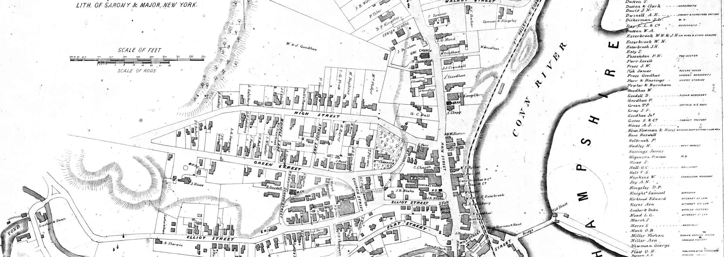
This middle section of the 1852 map shows the Main Street area at a time of great changes in Brattleboro. The railroad, just completed, was now a through route, and gave Brattleboro high-speed access to cities to the north and south. Business and private travelers needed places to stay, and this map shows several hotels: the Central House, the Revere House and the American House (here labelled “Hotel”). The “J. Fisk” by the Revere House was its owner, James Fisk Sr., father of the notorious “Jubilee Jim” Fisk who, after he left Brattleboro, went on to fame and fortune as one of the 19th century robber barons. Fisk was murdered in 1872 in New York City and his remains were brought to this building to lie in state before his funeral. The services were held in the Baptist Church which by that time was on Main Street in its present location (on this map the church is still on Church Street). Fisk’s gravesite is marked by an ornate monument in the Prospect Hill Cemetery on South Main Street.
The Wesselhoeft water cure establishment (“Dr. Wesselhoff”) had many patients at its Elliot Street clinic in 1852.
Note the lands just north of the High Street/Main Street intersection, and compare this area with the 1856, 1869 and 1895 maps which follow. In the next several years the Town Hall and two churches will appear on the maps.
The Center School at the top of this section of the map is the school built about 1833 to serve all grades. This old school was replaced on this site by a newer and much larger building in 1878, which was Brattleboro High school for many years, and is now the Municipal Center.
======================================================================================================================================
 Map 29 1852 Bottom Section
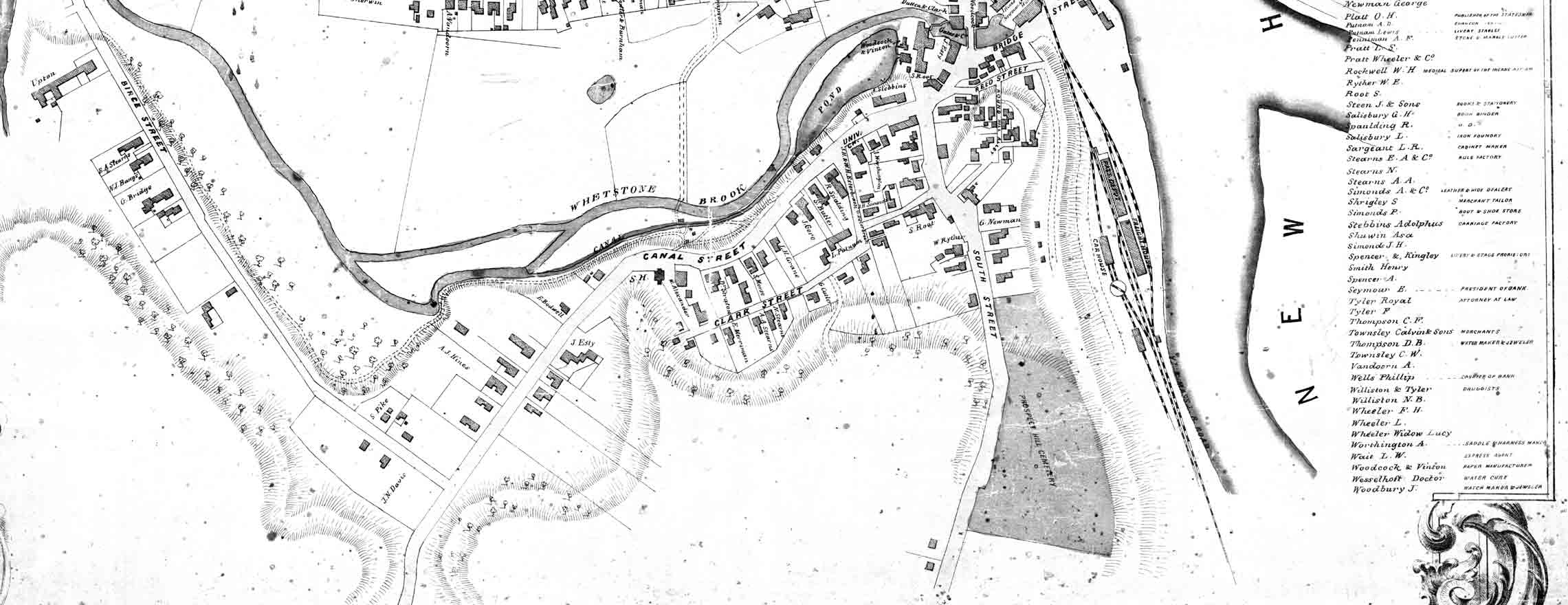
On the south side of Canal Street is the home of Jacob Estey, the owner of the Estey Organ Factory. The open hillside to the southeast of his house is now filled with houses in what is now the Prospect Street / Washington Street area. The enlarged inset map to the left shows the area around the outlet of Whetstone Brook. The street labelled “Mill Street”, near Whetstone Brook is now called Arch Street. As noted earlier this is one of the oldest roads in Brattleboro, for it was the connector between the river and Main Street. At the river’s edge in the earliest days, there were wharfs to load and unload barges. The “Hotel” site was previously used for a freight warehouse. “Hines, Newman & Hunt” were operating a machine shop and steam-powered flour mill according to the Subscribers Names. The outlet of Whetstone Brook is not visible because the stream ran beneath the machine shop. The Riverview Restaurant now occupies part of this old manufacturing site. Steam-powered motors were beginning to replace water-powered facilities by the mid 1800s. The large pond on the left side was a mill pond made to power the Woodcock & Vinton paper mill. This mill started a few years before this map was made, and continued until the 1930s. The pond is now a parking lot.
======================================================================================================================================
 Map 30 1856 from the McClellan Map of Windham County
This 1856 map is part of the large wall map of Windham county. The areas of Brattleboro not shown on this map are on the companion map on page 55. The McClellan map provided images of several old buildings in the map’s margins. Among these are the Brattleboro retreat and the old Estey Organ facility near the Main Street bridge.
There are a few new houses compared with the 1852 Presdee & Edwards map. Of note is the octagon house owned by Riley Burdett at the corner of Main and Terrace Street (the street is not named yet) opposite the town common at the top of the map. Burdett was a co-owner of the Carpenter Organ factory. This house can also be seen on the Batchelder bird’s eye view on the next page.
Just north of Burdett lived Silas M. Waite (here spelled Wait). Mr. Wait was a prominent Brattleboro businessman whose career ended in misfortune. He was an merchant, a developer and became President of the First National Bank. He worked his way up in the bank, becoming Cashier (see the business listing on the 1869 map) and finally the President. The bank failed in 1880, leaving many people in Brattleboro and elsewhere with large losses. Waite fled Brattleboro amidst charges of forged documents and embezzlement. He was tried later, and served some time in jail.
Note the “School House” on the common, on the east side of Asylum Street (Linden Street). This is the Chase Street School, which was moved shortly after this map was made to the corner of Chase and Linden Streets, as seen on the 1869 map.
Between Elliot Street and Green Street (middle of map), labelled “Dr. Wesselhoeft’s”, was the famous Water Cure Establishment. A bit south of that site was the Lawrence Water Cure, located at the site of the new parking garage. This latter business was completed in 1856. A co-owner was Charles W. Grau, who had previously worked for Wesselhoeft. Grau was also the author of the “Brattleboro & Vicinity” map reprinted in part on page 56.
Prominent on this map is the “Town House”, (capitalized for emphasis on the map) on the east side of Main Street. The Town House was only two years old when this map was made (on the 1852 map the land is vacant).
Prior to 1854, town meetings were held in West Brattleboro. Great controversy surrounded the plans and the final decision to move the Town Hall from its historic, central location to the east village. This building stood until the mid 1950s. For more details about this old Town Hall, refer to the fire insurance maps at the end of this volume.
======================================================================================================================================
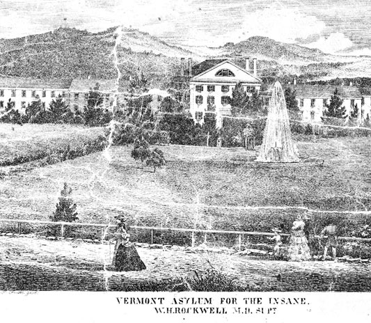 The McClellan wall map had several pictures in its margins. The Retreat’s view on this map is similar to that on the 1852 map.
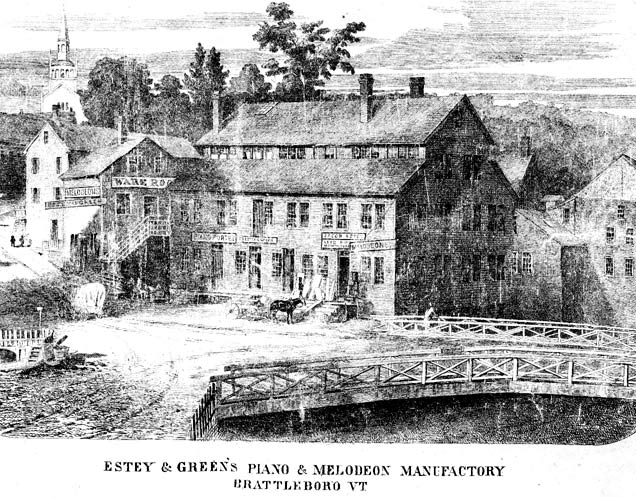 The Estey factory building on Canal Street near the Main Street bridge.
======================================================================================================================================
Map 31 1856 Batchelder View
The earliest published panorama of Brattleboro is this expansive view of the village from Mt. Wantastiquet, drawn by John Batchelder. In the downtown inset at left, we see the Lawrence Water Cure, (large building at top) near the Wesselhoeft Water Cure Establishment and the Baptist Church (top center) The large mill building on the left edge of this view is the Estey Organ Factory at its old site.
======================================================================================================================================
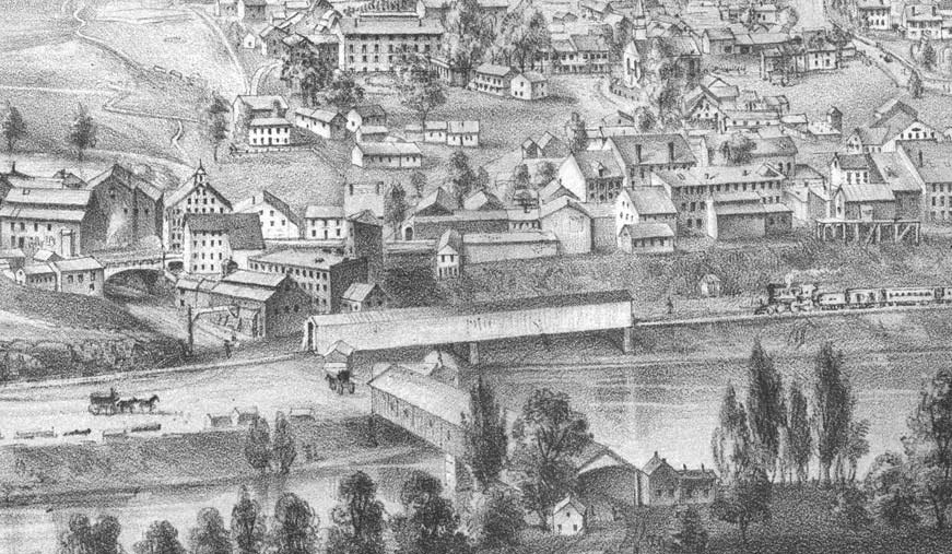 Map 31 Enlarged Detail of Downtown Brattleboro
======================================================================================================================================
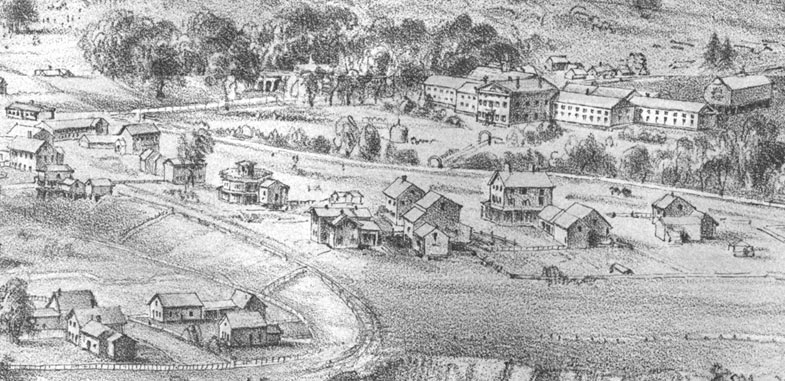 Map 31 Enlarged Detail of Brattleboro Retreat
The inset to the right shows houses on Terrace Street (left foreground) and the Brattleboro Retreat.
Note the octagon house on Terrace Street, the home of Riley Burdett.
======================================================================================================================================
7b Landowner Maps & Views DOWNTOWN 1869 – 1886
 Map 33 1869 Beers Atlas TOP
By 1869 much had changed in Brattleboro. The effect of the railroad with its easy access to distant markets led to the establishment of many more businesses, and the population grew and changed.
The Beers atlas provides us with these maps and the matching town map on pages 58-9, and the West Brattleboro map on page 51.The village of Centreville with its mill sites and cluster of houses, was mapped as a separate inset on the Beers map.
In 1869 St. Michael’s Catholic Church was built on Walnut Street (“R.C. Church”). The Baptist Church is shown at its modern location on the west side of Main Street; it was being built when the Beers atlas was published. Across the street was the site of St. Michael’s Episcopal Church, built there in 1858. This building was moved to its current home on Putney Road in 1953.
There are several new streets with houses not seen on the previous map, among them Oak, Grove, North and Tyler Streets. The Grove Street shown here is now called Forest Street; today’s Grove Street (not shown here) connects Oak & Main Streets, as seen on the 1895 map on page 45.
On the left side of the map is a new development off Western Avenue. Forest Square on this map is now Myrtle Street, and the two unnamed streets are the beginnings of Spruce Street and Cedar Street, which was not to go through to Linden Street until almost 1895 (see the 1895 map, page 43).
This is the last map to show Main Street before the big fire of 1869. In that year an entire block of downtown Brattleboro burned, destroying all of the buildings on Main Street between Elliot Street and High Street including the Brattleboro House.
======================================================================================================================================
 Map 32 1869 Centerville from Beers Atlas
======================================================================================================================================
 Map 33 1869 Beers Atlas BOTTOM
The growth in Brattleboro since the 1856 map is striking in some places. Prospect Street, Washington Street and Pine Street have now been laid out, connecting Canal Street with South Main Street. Dozens of new houses are now on the map in this area.
But the Estey Organ factory has yet to move to Birge Street. Estey’s operations were still, in 1869, being conducted in mill buildings nearer to the village center. There are several empty lots on Birge Street (top left) which will be the future site of the Estey Organ Company (see the 1895 map on page 44).
Near the middle of this map the property of “G.C. Hall” is now the site of Brattleboro Memorial Hospital.
The Beers atlas provided a Business Directory. The availability of such a listing was part of the sales appeal of the atlas, especially to the entrepreneurs whose names were listed next to their businesses. In fact, these listings were probably paid listings, just as are the telephone “yellow pages” listings of the present day. Note that a few private residences are listed under “Miscellaneous” without any associated business. These people are probably subscribers to the atlas who paid a little extra to have their names printed here.
======================================================================================================================================
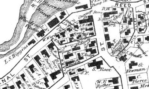 Map 33 Detail of the Canal Street / Clark Street area
======================================================================================================================================
 Map 34 Bailey & Hazen View 1876
The 1876 bird’s eye view, from an almost vertical perspective, shows more detail than the earlier view. Most streets are named, and buildings are shown in considerable detail.
The diagonal road leading off the map’s horizon to the left is Canal Street. In the upper left corner is the large house of Governor Levi Fuller, now the site of the Eden Park Nursing Home. At the top center we see the new factory buildings of the Estey Organ Company. Those eight buildings were built close for efficiency, but separate for fire safety.
Also newly built in 1876 were the Brooks House and the Crosby Block on the west side of Main Street. This view extends only a short distance out Western Avenue, so Centreville and West Brattleboro are not shown.
On the right (north) side of the view is the Brattleboro Retreat, with two new wings added since the 1869 map. This view shows us three covered bridges, the largest being on the road to the island. This is the same bridge as seen on the other views.
The railroad bridge over Whetstone Brook appears to be smaller than it was on the 1856 view, but this may be a result of artistry rather than fact. There is now a stone arch bridge here. Note also the small covered bridge on Elm Street over Whetstone Brook.
======================================================================================================================================
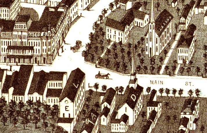 1876 Detail of Brattleboro’s Main street at High Street.
The Brooks House is on the left; the old Town Hall is in the foreground labelled “E”.
======================================================================================================================================
 Map 35 1886 Brattleboro by Lucien Burleigh
The 1886 view, the last of the 19th century views of Brattleboro, shows a much more developed town.
In the upper left we see the Creamery covered bridge and Guilford Street extension leading south (left) and Western Avenue extending off to the west. The Creamery Bridge was built in 1879, and is in regular use today. The bridge was named for the Brattleboro Creamery which was on the south side of the bridge – see the lower right corner of the 1895 map on page 53.
Orchard Street extends northerly from Western Avenue through open fields. The Centreville settlement at the beginning of Orchard Street had a large mill building in 1886 – the Bickford Knitting Machine company.
On the bottom left of the view is South Main Street, and the Prospect Hill Cemetery. Note the busy railroad facilities along the river. The large building near the bottom of the view is the freight house, where merchandise was stored for shipment and delivery.
The covered bridge over the railroad is gone, replaced by a stone arch bridge built in 1878 which is barely visible in this view. There is a prominent new railroad feature: the turntable along the river below Walnut Street. The building at the end of the covered bridge on the island is the toll house, where fees were collected for the use of the bridge. A private company owned and operated the bridge at this location until 1888. The bridge itself lasted fifteen more years; it was dynamited in 1903 to make way for a more modern structure.
======================================================================================================================================
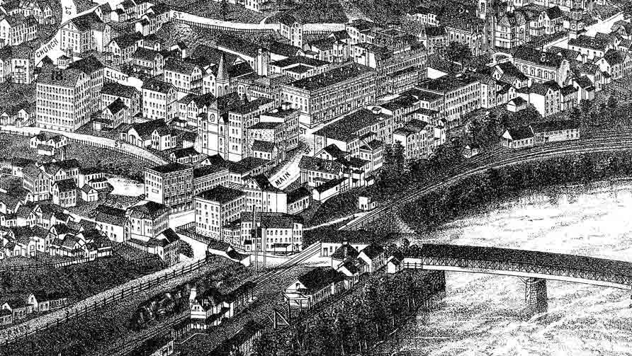 Enlarged detail of Downtown Brattleboro in 1886
The detail to the right shows the remarkable detail of the Burleigh view.
Prominent in this excerpt are the Crosby Block and Brooks House on Main Street, and the 5-story Carpenter Organ Factory on Flat Street, near the site of the recently built (2003) parking facility.
======================================================================================================================================
7c Land Ownership Maps DOWNTOWN 1895
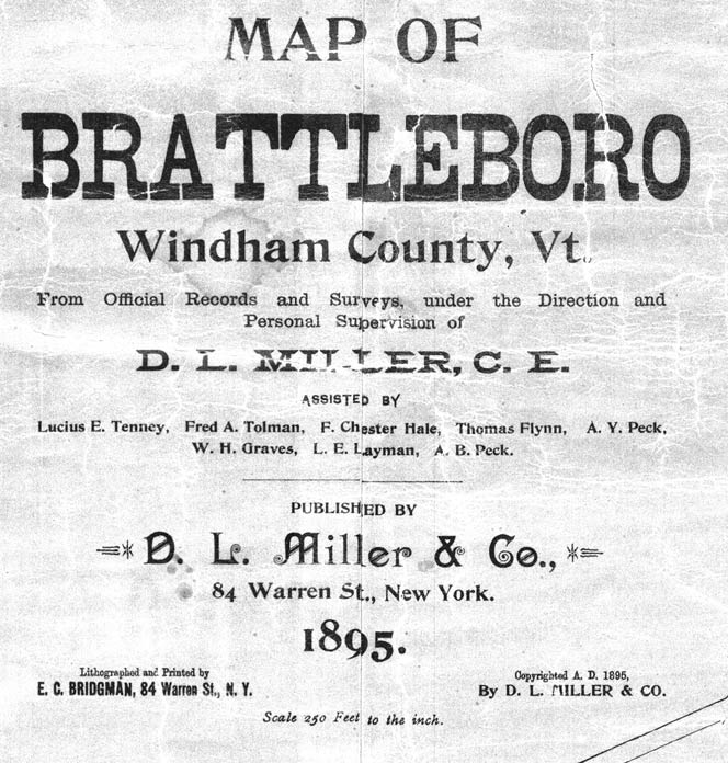
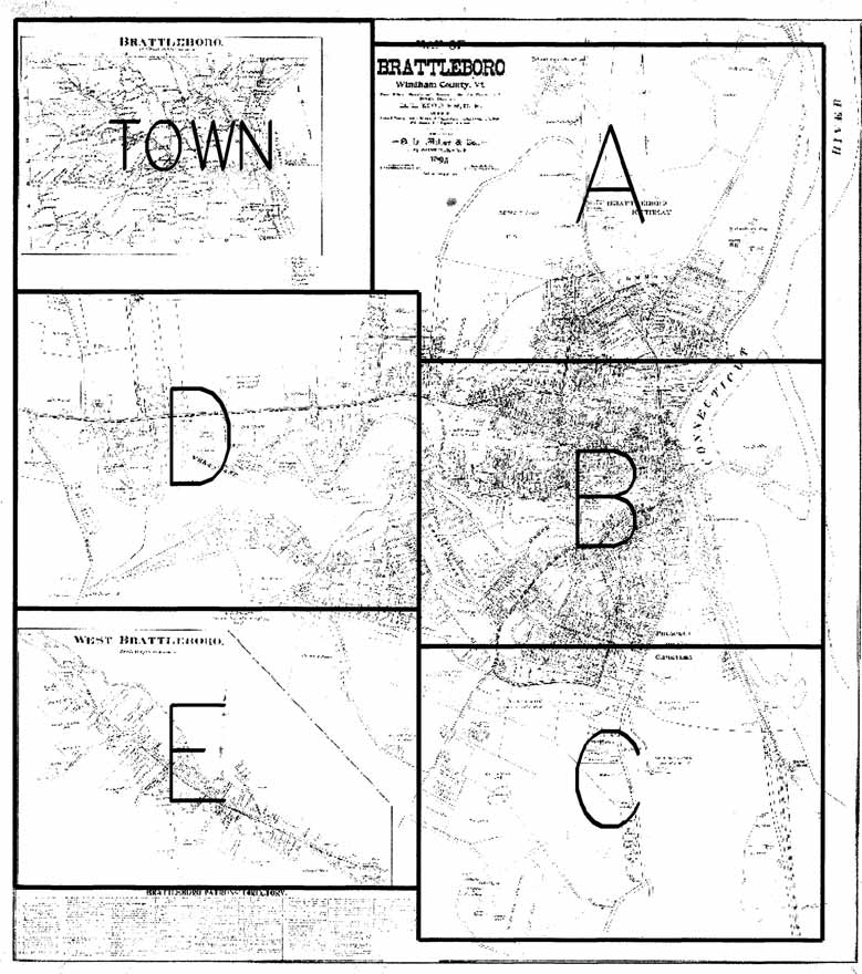
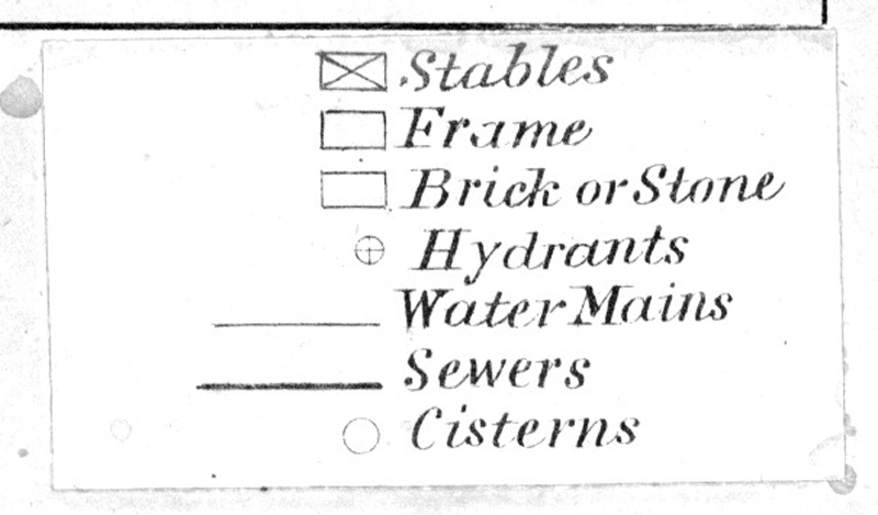
Map 36 1895 D.L. Miller Map
Our next map, the D.L. Miller map, is the largest of the old maps of Brattleboro; the original map measures about 42” x 60”.
It is reproduced here on several separate pages. There are three separate map sections: downtown Brattleboro, West Brattleboro, and the entire town. The downtown section occupies most of the map – it is reprinted here in four sections (A,B,C & D) on the next eight pages.
The West Brattleboro portion (E) is printed with other maps of that village on page 53. The Town map is on page 63. A small Key Map is added to help the reader with location.*
======================================================================================================================================

The map reveals many changes from the prior 1869 Beers map. The Brattleboro Retreat has been given its modern name, as has Linden Street. The Retreat Tower (“Tower”) was completed in 1893 – just two years before this map. The large open area on the right side of the map is the Retreat Meadows, then open pasture lands, which are now under the backwater from the Vernon Dam, which flooded this area beginning in 1909. The Chestnut Hill Reservoir, completed in 1884, served a number of houses in Brattleboro. This was a private water system owned by George Crowell, who lived in a palatial residence called Lindenhurst, seen on the next page, at the corner of High and Green Streets. (The house site is now Town property – Crowell Park.) A water system was a big improvement over private wells, and the mapmakers showed water lines and pipe sizes (“4 inch”). The building next to the reservoir is sometimes referred to as the “Fresh Air House” – where children from the cities could come for some relaxation. It burned in 1913 .
In 1895 the high school was at the corner of Main Street and Linden Street. The school was built in 1884 and still stands today as the Municipal Center. The interior is remodeled, except for the Brattleboro Historical Society’s room on the third floor, which still has some of the old school’s features. The old town library was located a few buildings south, where the Post Offfice parking lot is now. 1895 was the year the trolley cars came to Brattleboro. The street railway routes are shown by the dark patterns in major streets. Great controversy surrounded the establishment of this modern transportation system. Those who objected, including Rudyard Kipling, who lived nearby in Dummerston, protested loudly, and even resorted to a court injunction to stop the railway. Their efforts failed, and by December of 1895 the trolley lines were carrying about 2,500 passengers a day. The street railway lasted until 1923, when the tracks were removed to make way for automobile traffic.
In 1895, when this map was issued, the Estey Organ plant was in full opertation at its site on Birge Street where the buildings still stand today. Organs and melodeons were made here for shipment all over the world. At its peak, 600-700 people worked for the Estey company. Several other facilities were owned by Estey, such as the sawmill on Williams Street (see page 48).
Some entries on these old maps raise questions. What was the “German Carp Pond” just below Birge Street. Was there a fish farming business here? That pond is now filled in. For many years it was an ice pond used by the Crystal Ice & Fuel company.
The Miller map provides a nice record of the island in the Connecticut River. This is before the island came in to recreational use as “Island Park” with ballfields, grandstands and other public features.
======================================================================================================================================
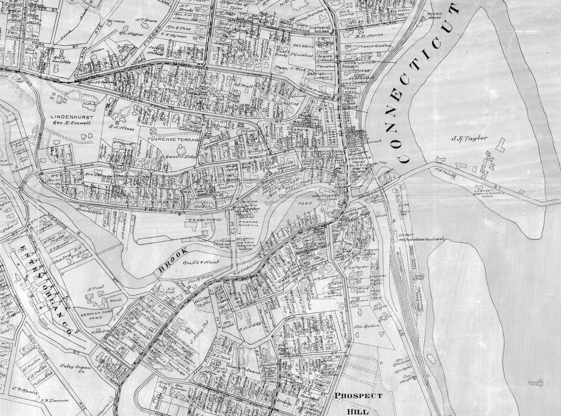 Map 36 1895 D.L. Miller Map B
In 1895, when this map was issued, the Estey Organ plant was in full opertation at its site on Birge Street where the buildings still stand today. Organs and melodeons were made here for shipment all over the world. At its peak, 600-700 people worked for the Estey company. Several other facilities were owned by Estey, such as the sawmill on Williams Street (see page 48).
Some entries on these old maps raise questions. What was the “German Carp Pond” just below Birge Street.. Was there a fish farming business here? That pond is now filled in. For many years it was an ice pond used by the Crystal Ice & Fuel company.
The Miller map provides a nice record of the island in the Connecticut River. This is before the island came in to recreational use as “Island Park” with ballfields, grandstands and other public features.
======================================================================================================================================
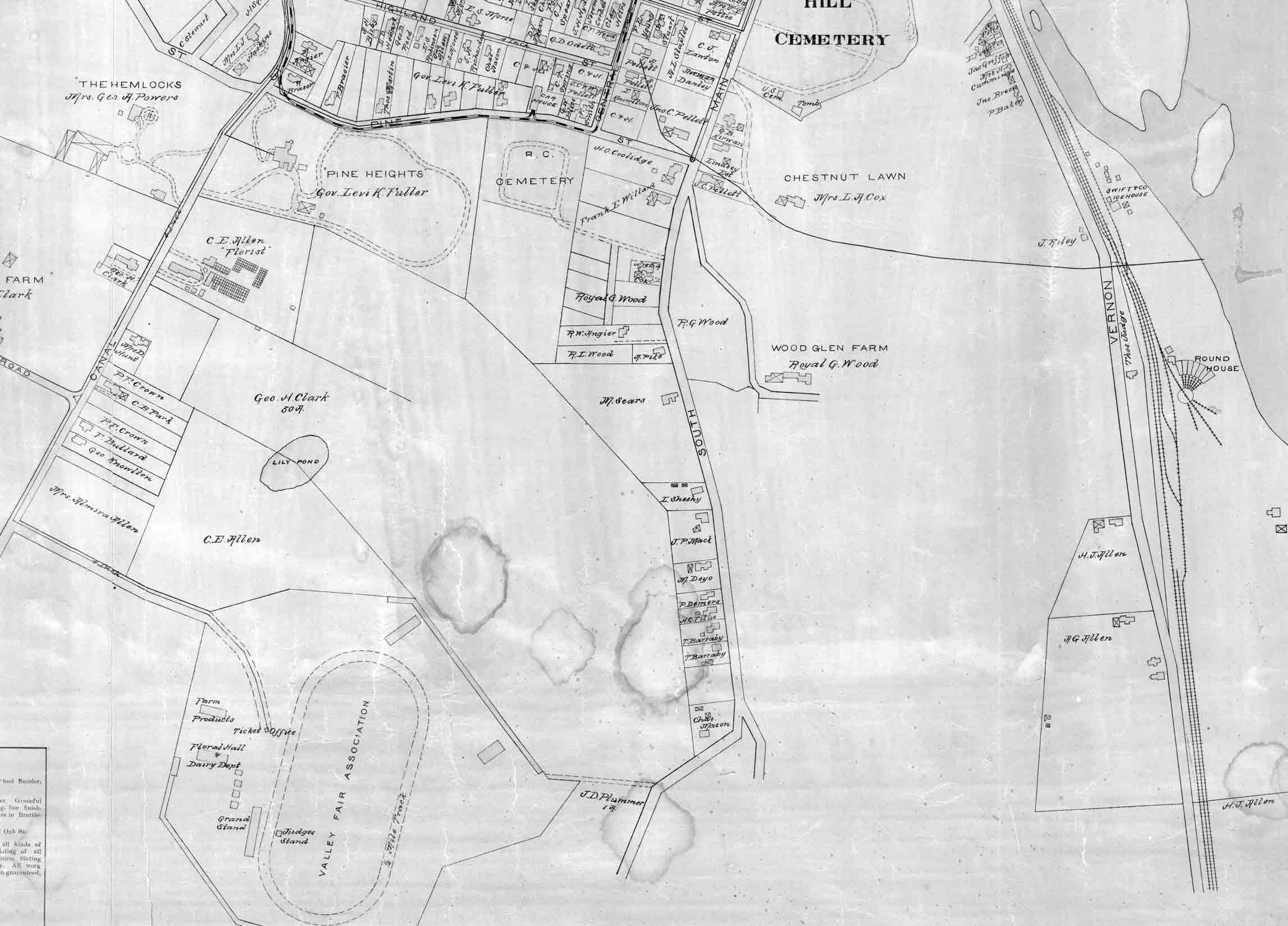 Map 36 1895 D.L. Miller Map C
The unnamed road in the lower left is now Fairground road – named for the agricultural fairgrounds which stood on the present site of Brattleboro Union High School. The “Lily Pond” is probably the same pond shown as “Turtle Pond” on the 1860 Grau map which follows on page 57.
Brattleboro was home to a Vermont Governor, Levi Fuller, who served from 1892 to 1896. Fuller lived in a large house at the corner of Canal Street and Pine Street, where Eden Park Nursing home is now located. In 1895 Fullers’ “Pine Heights” was one of the most magnificent estates in Brattleboro. Governor Fuller was born in Brattleboro, and was associated with the Estey Organ Factory during his working years.
By the 1890s, several other Brattleboro residents were able to afford commodious houses, and some are seen on this map labeled with their familiar names like “Chestnut Lawn” and “The Hemlocks”. Interestingly, hemlocks are still standing on the site of the latter home on Canal Street, now used by Brattleboro Memorial Hospital. The first hospital was built here in 1903.
The open areas on the 1895 map are now filled with roads and houses. Oak Grove Avenue and Clark Avenue now pass between Canal Street and Main Street, and Fairground Road is now a through road.
The Miller map features a “Brattleboro Patrons Directory, which is printed on the West Brattleboro map on page 53.
======================================================================================================================================
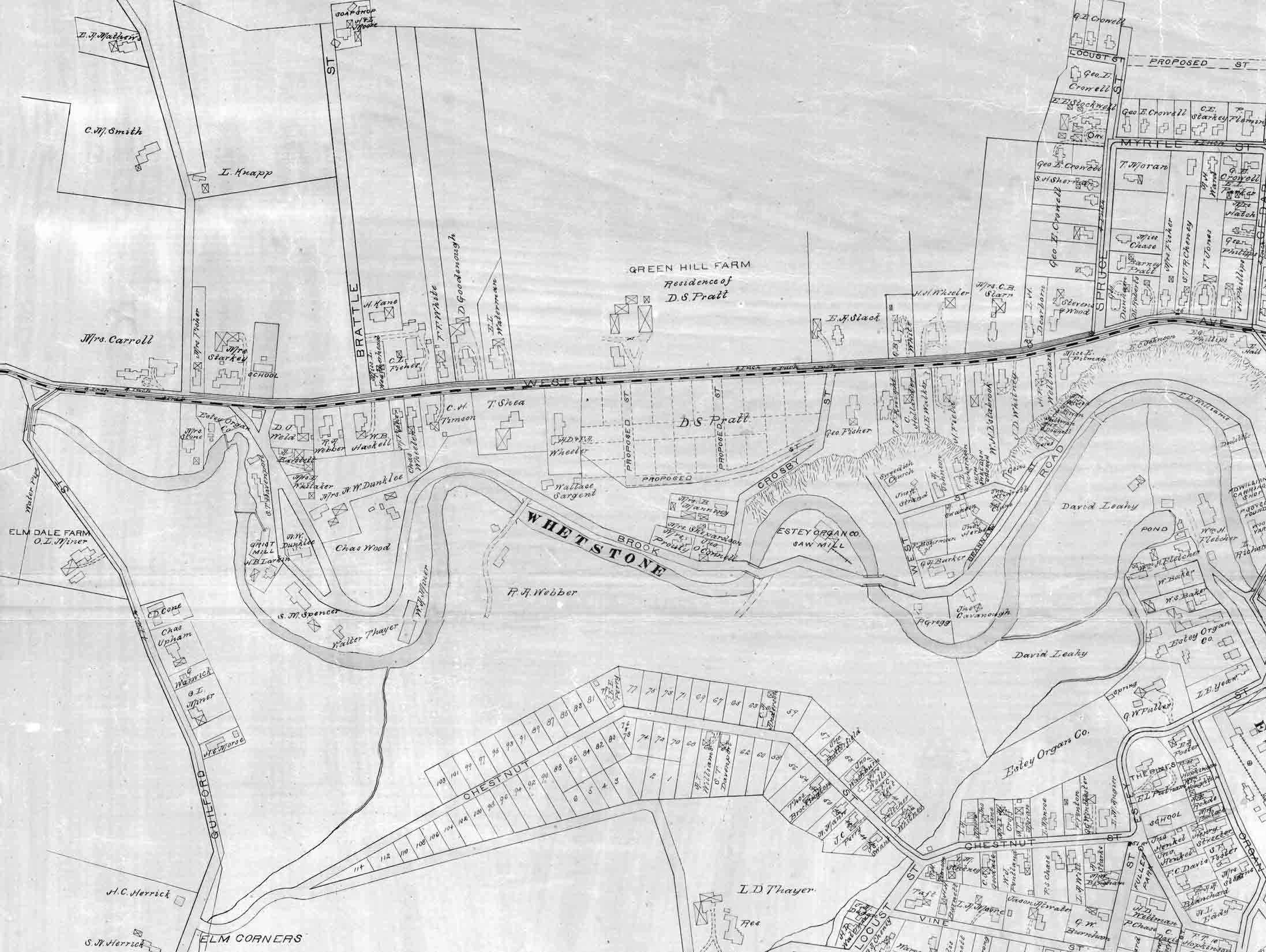 Map 36 1895 D.L. Miller Map D
On the left edge of this portion of the Miller map is the Creamery Bridge over Whetstone Brook, a covered bridge even then. “Centreville” village (not labelled as such on this map) is the area around the next intersection to the east, where Williams Street (here called Brook Road) meets Western Avenue. Note the two mill dams close to each other serving separate facilities. The Centreville chool on the north side of Western Avenue is now the Phoenix House.
Highway Interstate 91 currently slices through this map, just to the right of Brattle Street, and to its east are two “new” streets, Allerton Street and Greenhill Parkway. The Green Hill Farm of D.S. Pratt has a much older history than even these old maps. This was the site where in 1861 a wooly mammoth tusk was found buried. The tusk – about three feet long- is preserved today in a case at the Brooks Library.
Several of Brattleboro’s neighborhoods have common names, among them are Esteyville and Swedeville. The 1895 map provides clues as to the origins of these names. In the lower right corner of this page (and page 44) is the Esteyville neighborhood (Chestnut Street, Pleasant Street etc.) next to the Estey Organ factory.
The area sometimes called Swedeville, on the north side of Whetstone Brook near West Street, was home to a number of Swedish-Americans in the late 1800s. Note the two churches a short distance from each other: the Swedish Church and the Lutheran Swedish Church. The latter was taken down in 1948 and replaced by the present Trinity Lutheran Church on Western Avenue. The “Swedish Church” is no longer a church, but the building stills stands today as a stained-glass studio. A newer road, Strand Avenue, now connects West Street with Western Avenue. The L.D. Thayer farm (bottom right) is now the site of the Austine School.
======================================================================================================================================
8 West Brattleboro
The 1856 map, from the McClellan wall map, is the oldest detailed map of West Brattleboro. 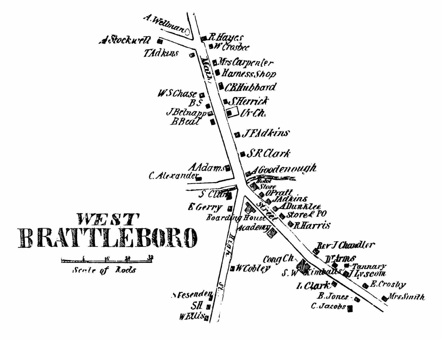 It shows the area along Western Avenue, then called Main Street, from Greenleaf Street (top) south to just above the Whetstone Brook bridge. Bonnyvale Road and South Street (here called High Street) bear off to the west.
Of special note on this map is the Hayes tavern site at the top of the map, labelled with the name of R. Hayes. This was the house built by Rutherford Hayes, a blacksmith, in the 1790s. One of Hayes’ grandchildren, Rutherford B. Hayes, would become President of the United States in 1877. The “R. Hayes” on the map is Deacon Russell Hayes, uncle of the President. The future President was born in Ohio, where his Brattleboro-born father (also Rutherford) was a merchant.
The First Congregational Church is seen at its present site, where it has been since the 1845. This building replaced the prior church building which stood just northeast of this location, within the roadway of Western Avenue. The older church, built in 1785 (and burned in 1842), was Brattleboro’s only church in early town history. It is the edifice shown on the Whitelaw maps earlier in this volume (p.16-17).
On the west side of Western Avenue, labelled “B. Beal”, is the house now known as the Jeremiah Beal house, now owned by the Brattleboro Historical Society. This house is supposed to be the oldest brick house in West Brattleboro.
In small print, at the three-street intersection in the middle of the map, is the word “Hotel”. This refers to the hostelry later known as the Glen House (see 1869 map). The Melrose Hotel was built on this site in the early 1900s, and, after that structure burned, a short-lived hospital was there.
======================================================================================================================================
Thirteen years later the map on the next page was published as part of the Beers Atlas of Windham County.
 This is one of four maps of Brattleboro in that atlas. The Beers maps provide the approximate shapes of properties as well as names, and more details including more accurate shapes of brooks and a Business Directory.
The Hayes Tavern is still in the same family (“Mrs. Hayes”), and across the street we can see the outlines of one of the two octagon-shaped houses in West Brattleboro.
The other is on Western Avenue across from the Congregational Church. This house was built by the Reverend Joseph Chandler, minister of the church at mid-century.
Another man of the cloth, Reverend Lewis Grout, lived on Greenleaf Street when this map was made. Grout is notable to us today because of his skills as an historian. Grout, a missionary, did original research and has left us several articles on the early history of Brattleboro.
======================================================================================================================================
The 1895 map of West Brattleboro is taken from the large wall map by D.L. Miller. 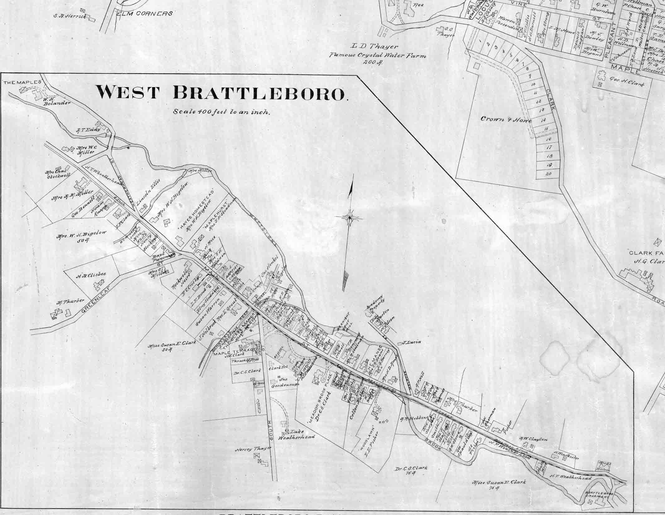 The letter “E” indicates the position of this excerpt on the larger map. Here we see more detailed house outlines, and even driveways. Several larger estates are given their personal names like “ Woodlawn”, “The Meadowbrook Place”, and “The Maples”.
West Brattleboro was served by a trolley line, and had public water (the map shows a 4” water line). The Hayes tavern is still in the same family. “Mrs W. H. Bigelow” was Mary Hayes Bigelow, first cousin to the former President. Other interesting features include the Brattleboro Creamery at the bottom of the page, next to the bridge we now call the Creamery Bridge.
The Miller map, like two of the earlier maps, had a listing of subscribers, both businesses and individuals. The listing is re-arranged in this edition.
9. Land Ownership Maps – Entire Town
The oldest of the “entire-town” property owner maps is the 1856 McClellan map, taken from the large county wall map. For the first time, all of Brattleboro’s roads are shown. By this time the settlement on Meetinghouse Hill is no more, and West Brattleboro and downtown area have grown so much that they are on separate maps (pages 50 and 30). The population of the whole town at this time was about 3900. Since there were no complete maps of Brattleboro the surveyors had to measure all the roads themselves, and get the names of the homeowners. The measuring devices were probably a wheeled odometer with a simple compass like the one pictured below.
19th century mapmakers used wheeled odometers to measure roads
The McClellan map, typical of many early maps, shows only the prominent hills. Maps like these do not attempt to depict mountains or other geographic features which are not obvious to people on main roads. The roads are not mapped as well as the later maps in this series, but we presume that this map does show all the roads in existence at that time, including at least five roads which are now abandoned. Most of the roads we have today, especially the through roads to adjoining towns, were in existence in 1856. One exception is Route 9 to New Hampshire, and the “Chesterfield Bridge” at that location.That road and bridge were not completed until 1889. This map omits the two islands at the Hinsdale bridge, but they were there, as seen on the small 1858 map on page 19. Route 9 to Marlboro (west) is the east-west road which has very few houses on it after it leaves West Brattleboro. The heavily built up east-west road below Route 9 is Ames Hill Road – the former through road to Marlboro.

Our next map is of uncertain date, but it may have been drawn about 1860. The author, C.W. Grau, was a physician at the Wesselhoeft water cure establishment. A part of the “cure” for patients was getting out into the country air. This map is an excerpt from the “Brattleboro and Vicinity” map, a guide to the surrrounding countryside. It extended as far as Spofford Lake in Chesterfield, New Hampshire and west to South Pond in Marlboro – both likely destinations for casual travelers.
The roads shown here are generally the same as those of the 1856 county map, and of the similar 1858 map of Cheshire County, New Hampshire. It is likely that Grau used these other maps as his base, hence the assumed date of about 1860. The roads on the Grau map are more attractively drawn than on the McClellan map, and a few more roads are shown.
Though no homeowner names are shown, a few locations are named, such as several large farms which may have welcomed visitors: Bliss Farm, Folsom’s Farm and Clark’s Farm. But what are we to make of the “Gipsy Ground” located across from the Brattleboro Retreat? The dashed line beneath those words is probably the route of Cedar Street, which may have been a trail at that time. Elevations above sea level are provided, and prominent hills are given names for the first time on a Brattleboro map. Ginseng Hill and Round Mountain are known by those names today. Grau’s map shows us hiking trails leading up to Wantastiquet Mountain and Mine Mountain on the New Hampshire side of the river. The larger mountain – Wantastiquet – had received this new name in 1852 according to Cabot’s Annals. The two islands in the river have different names than they did on the 1830 canal map. Goodhue’s, the larger island, was named for Francis Goodhue, a large landowner in Brattleboro who, among other enterprises, had a river freighting business. It is interesting that the author gives us the area of each island – 39 acres and 19 acres. Note also the feature “Turtle Pond” in the lower right corner. That pond is probably the large depression known as the kettle hole near Brattleboro Union High School.
The ferry crossing to Chesterfield, New Hampshire, the “Norcross Ferry” is seen just below Catsbane Island. There was no bridge crossing in this part of Brattleboro until 1889. The road at the foot of Wantastiquet Mountain on the New Hampshire side, now unused, was the direct route to Chesterfield. A later edition of this map, slighty revised, is printed on page 60.
The 1869 map of Brattleboro comes from the Windham County Atlas published by the F.W. Beers Company. The Beers map is quite complete like the 1856 McClellan map, but it is more accurate, and adds new information. Not only does it show all roads and homes, but smaller streams are shown, indicating that the surveyors did some off-road work to make these maps. School districts are defined, and the map is accompanied by a Business Directory. Of special note is the accuracy of the road positioning. The Beers company probably did original surveys of these roads, because they are much more carefully placed than on the Grau and McClellan maps. The surveys were probably done with an odometer like that pictured on the page 54, but the surveyors of this map clearly did a better job. Another part of their job, like the McClellan surveyors, was to sell their atlases to the residents of Brattleboro. They probably carried samples of other atlases the Beers company had produced, and showed them to the homeowners as they passed by making their new maps.
This map shows us why the small village called Centreville got its name. Now only a intersection marked by the Vermont Country Deli, in the mid 1800s this was a distinct small village situated midway between the two principal villages of the town.
The two maps on this page are not of much value as “land-ownership” maps, but they are included because they show the extent of the road network in the 1880s. The Grau map of Brattleboro and Vicinity (page 57) was reprinted, with modifications, some time around 1880, and our next map (Map 43) is a copy of that later edition. The date derives from the fact that the West River Railroad is shown, a feature which did not exist until 1880. This dating technique is not certain however, as mapmakers will sometimes draw a proposed road on a map, so that the map will not become quickly outdated. Although Grau’s name appears on this edition of the map, he was not the author, as he had died in 1861. This second edition of the map was printed as a full-size map (22” x 27”) and as a reduced-size fold-out map in a small hardbound case. In addition to the West River Railroad, there are a several houses shown which were not indicated on the circa 1860 map.
In 1884 the “Gazetteer of Windham County” appeared, a four hundred page book filled with historical text of all the towns in Windham County. A fold-out map was included in the back of the book. The Brattleboro area of that map is reprinted here, slightly enlarged. Each road was numbered so that the book’s Business Directory could refer to the map easily. The map does not add much to our knowledge of roads in Brattleboro. The roads and town outline appear to be based in the Beers map. One bit of new informatioin is the depiction of the West River Railroad. The railroad began its life as the Brattleboro & Whitehall Railroad, implying that it would run to Whitehall, New York, but it never got past Londonderry, Vermont. The rail line was not very successful, and ceased operations in 1936. Some feature names on this map are different than todays: North Pond in Marlboro is now called Sunset Lake Road and Marlboro Pond is now South Pond.
The last of Brattleboro’s detailed town maps is the 1895 map from the Miller wall map. This is a small portion of the much larger map – see also pages 42-49 (downtown) and 53 (West Brattleboro). The Miller map shows us all roads and homeowner names, and adds road names for the first time.
Mapmakers sometimes make errors, and there are two obvious omissions on this map. The West River Railroad is not shown although the line was in active use in 1895. Also missing is the Chesterfield Bridge over the Connecticut River (at today’s Route 9), which was built in 1889. The topographic map on the next page, made two years earlier than this map, shows both features.
By the late 1800s, the standard of living had improved and more people had time for leisure pursuits such as walking. The Miller map shows, quite accurately, the trail which leads to the top of Wantastiquet Mountain.
Some farm sites have their acreages shown, and distances (in rods) are given between road intersections (one rod equals 16.5’).
The school houses, still scattered throughout the map, are more numerous than on the 1869 Beers map, and have been re-numbered.
There is an interesting sketch map (shown below) among the papers of Rudyard Kipling, the noted author who lived for a few years in Dummerston, just over the town line. Kipling’s regular carriage route to Brattleboro took him down Putney Road (Route 5) and across the West River highway bridge, where two railroad lines crossed the river as well. Apparently the trains would occasionally spook Kipling’s horse, and he feared an accident. Kipling wrote a letter to the railroad in 1895, requesting that trains sound their whistles before approaching this bridge. His letter included this small, but attractively drawn map, complete with a graphic warning of the consequences of an accident.
Most 19th century road maps were made by private businesses, the previous four maps being examples. It was not until the late 1800s that the United States government started making maps. The “USGS quad sheets” so familar to sportsmen and latter-day explorers were the result of more accurate surveys than those done by the commercial mapmakers. The Brattleboro sheet was published in 1893, based on field surveys of 1889. The goal of this mapping effort was to map the entire country in a systematic manner. All roads and major buildings were mapped, all waterways and, most importantly, topography. The drafting of contour lines allowed for accurate depictions of hills and valleys, and made it possible to design new roadways and other developments with much better planning than was possible before these maps were made. Engineers could, for the first time, understand which areas of the land were subject to flooding, and design protective structures like dams and levees. These maps are less attractive to the eye than the older maps because they are so full of information. While they were supposed to be near perfect, there are errors. One obvious mistake on this map is the omission of Halladay Brook in the northwest corner of town. That brook runs through a notable ravine which extends from Sunset Lake Road westerly across the town line into Marlboro. The map shows a short, small stream, and none of the ravine. Oddly, the 1869 Beers map shows the brook more completely.
Note the locations of the two railroads serving Brattleboro – the New York, New Haven and Hartford line and the West River Railroad (then called the Brattleboro and Whitehall Railroad). The second trunk line from the south, the Boston & Maine Railroad which came through Hinsdale, New Hampshire is not shown as it was not completed until about 1913.
10. Fire Insurance Maps – Main Street
Very detailed maps of buildings in downtown Brattleboro were made over a period of several decades by the Sanborn Map Company. These maps were made so that insurance companies in distant cities could assess the fire risk of a given property. They show us the actual shapes, materials and uses of the old buildings from 1885-1925. On these two pages we reprint a portion of the oldest fire insurance map, dated 1885, followed by similar excerpts from the 1912 maps. These two pages are top and bottom of the same map, showing Main Street from High Street to Elliott Street, Flat Street and Bridge Street. This first map is reproduced from a microfilm copy and the details are a bit difficult to read.
The area of the present Harmony Parking Lot was a public park in the 1880s and the Brooks House dominated that side of Main Street, as it does today. The building had a number of small shops in it in 1885, just as it does today. In fact all of Main Street is filled with small businesses. Merchandise sold in the late 1800s was similar to what we buy now: silverware, jewelry, books, stationery and “dry goods”.
At the top of the map (left) we see the Baptist Church, at its present location, then only a 13 year old building. The map 67 records the height of the building, including the steeple – 135’ tall. The heating and lighting are mentioned, notably the gas lights, important facts for fire insurance. The old Town Hall was a large building with a meeting room, library and Town Clerk’s office. Those offices are familiar to us now, but there is no “Auction Rm.” in the current Municipal Building. On the east side of the street is the “Hooker Block”, a building which still stands today, though greatly expanded by the addition of the Dunham building on the river side. The 1912 fire insurance map on the next page shows the larger building. The West River Railroad began in Brattleboro, and its tracks are labelled here “Brattleboro and Whitehall narrow gauge R.R.”.
Just five years before this map was made, the Methodist Episcopal Church was built on Elliot Street. This is the building now used by the Hotel Pharmacy. Across the street, at the corner of Elliot & Main, we see the entry “Nat. Bank” at the site where the Chittenden Bank continues to offer financial services today. Further down the map, on Flat Street, is the “John L. Ray Livery”, an establishment where one could rent a horse and carriage and buy related supplies. We note that Mr. Ray’s business sold trunks and blankets, both of which are sold by the current occupant of this site, Sam’s Department Store. The Ray building had a “Second story level with St.” just as the Sam’s store does today, although this 1885 building is not the same as today’s building.
On the bottom of the map (right page) is the outlet of Whetstone Brook, with a dam and two water-powered mills. Note the details offered to the fire insurance companies: a listing of the heating and lighting fuels, and the fact that there is “no night watchman” at each of the mills. The “driveway” just above the machine shop is Arch Street, which was named for the arched railroad “stone bridge” at the end of the street. That stone bridge was built in 1878 and is still in use today. The numbers in front of the buildings are the street numbers. Note that the numbering system is different on the next map.
The last map is a portion of the 1912 fire insurance map of downtown Brattleboro, the section of Main Street from High Street to Bridge Street. Prominent on this map is the Manley Brothers automotive garage, in the middle of what is now the Harmony parking lot. Cars were just beginning to be widely used in Brattleboro. The Model T, the first economical car, went into production in 1908, and soon became a common sight on Brattleboro streets.
The Town Hall had a sizeable auditorium in the rear, the “Festival Hall” on this map. Concerts, plays, speeches and other public events were held there, as it was the largest enclosed public space in Brattleboro. The building was over fifty years old when this map was made (built in 1854) and would be used for four more decades. The Main Street Gallery now occupies this site. By this time, on the east side of the street, the Dunham Brothers have built a large warehouse served by a railroad siding.
The livery stable at the corner of Flat Street is not as prominent as on the earlier map. Services for horses were less needed now that cars were coming into wide use. In fact, a year after this map was made, this building came down, replaced by the present building which houses Sam’s Department Store. Another sign of a more modern world is the Gas & Electric Company on Arch Street at the site where water-powered mills used to turn. The old American House, seen on the 1885 map, has by the time of this map been torn down, and in its place is the current American Building.
Fir Insurance Maps – Main Street
11. The Brattleboro Town Charter – December 26, 1753
250 years ago, in December of 1753, the Colonial Governor of New Hampshire “chartered” Brattleboro by issuing this document. Refering to the loving servants of the King of England, this charter delineated the reasons for establishing a new town, described the boundaries, and listed the men who were given this land – the original “grantees”.
The grantees had to do certain things like cultivate the land and make other improvements, and were forbidden to cut any tall pine trees which might be suitable for the Royal Navy. They were told that after fifty families were settled they “…shall have the liberty of holding two fairs, one of which shall be on the first Thursday in October annually, and the other on the first Thursday in February…”.
The charter also includes a written description of Brattleboro and of three interior parcels of land, a 200 acre tract belonging to Oliver Willard, a small tract around Fort Dummer reserved for the King, and 800 acres reserved for the Governor himself.
Sketches of the language describing these three tracts have been drawn to make it easier to read this old document.
===The Bratteboro Charter with Sketches interpreting the land tracts =============
Province of New Hampshire
(L. S.) George the Second, by the Grace of God, of Great Britain, France and Ireland King, Defender of the Faith, &c.
To all persons to whom these presence shall come, greeting:
Know ye that we of our special grace and certain knowledge and mere motion, for the due Encouragement of settling a new plantation within our said Province. By and with the advice of our trusty and well-beloved Benning Wentworth, Esq., our Governor and Commander-in-Chief of our said Province of New Hampshire in America, and of our Council of the said Province, have upon the conditions and reservations hereafter made, Given & Granted and by these Presents for us our Heirs & successors Do Give and Grant in equal Shares unto our Loveing Subjects Inhabitants of our said Province of New Hampshire and his Majesty`s other Governments and to their heirs and assigns forever whose Names are Entered on this Grant to be divided to and amongst them into fifty-six shares,
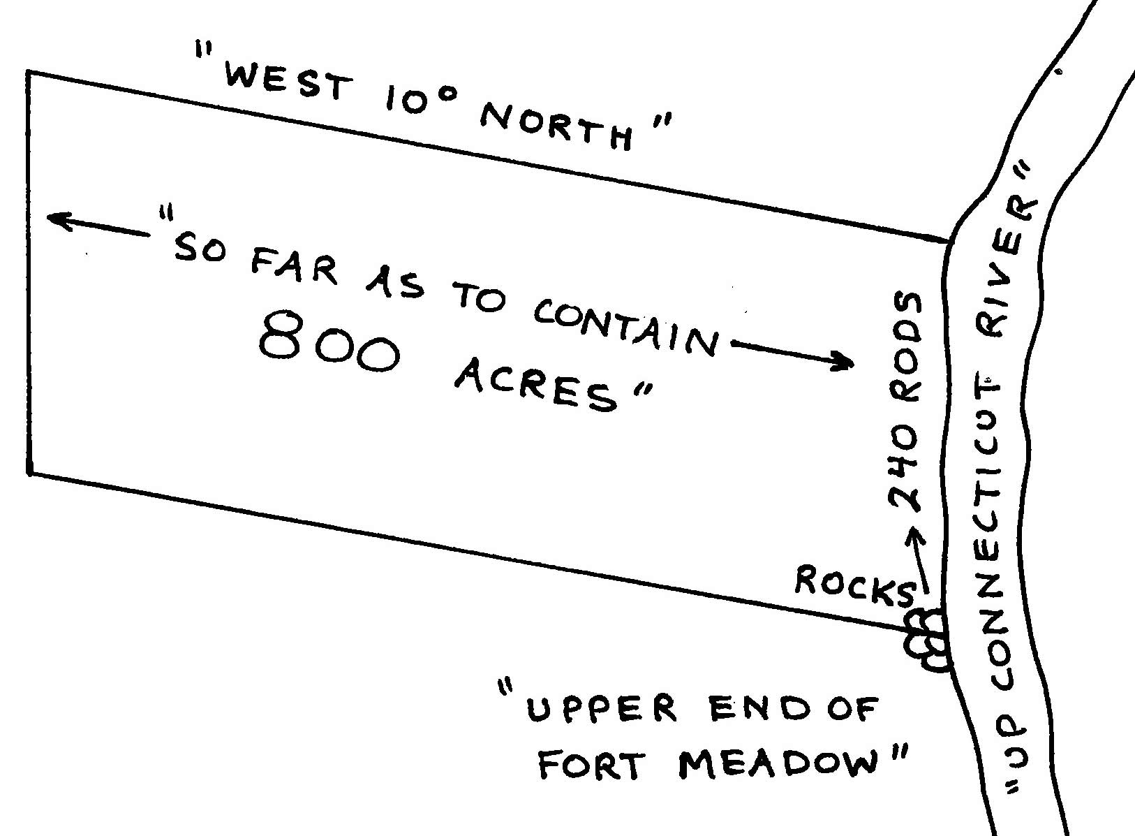
Two of which shares to be laid out in one Tract of the contents of Eight Hundred acres for his Excellency Benning Wentworth, Esq., and is in full for his two shares, which Tract is bounded as follows, viz: Beginning at the rocks at the upper end of the Fort meadow so called. Thence up Connecticut River Two hundred and forty rods, & to carry that breadth back West ten degrees North so far as to contain Eight Hundred acres.
======================================================================================================================================
All that Tract or parcel of Land situate, lying & being within our Province of New Hampshire containing by measurement Nineteen Thousand Three Hundred and sixty acres, which Tract is to contain five miles and one-half mile square & no more, out of which an allowance is to be made for high ways & unimprovable lands by rocks, mountains, Ponds & Rivers, one thousand and forty acres free according to a plan thereof made & presented by our said Governors orders & hereunto annexed, Butted & bounded as follows, viz:
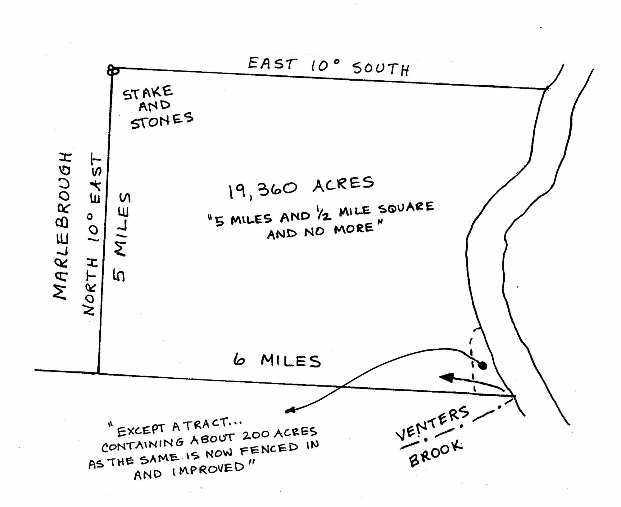
Beginning at the mouth of Venters Brook so called where it empties itself in to Connecticut River, & runs from thence six miles or thereabouts to the South East corner of Marlebrough thence five miles, North ten degrees East by Marlebrough aforesaid to a stake & stones in said Line. Thence East 10 degrees south to Connecticut River aforesaid, then down said River to the bounds first mentioned at Venters Brook,
Except a Tract of land lying in the said East corner of said Township containing about Two Hundred acres as the same is now fenced in and improved, which is hereby granted & assigned to Oliver Willard and to his heirs & assigns one. of the within Grantees, He having heretofore cleared and improved the said Tract and is to be in full for his share & proportion of the said Township,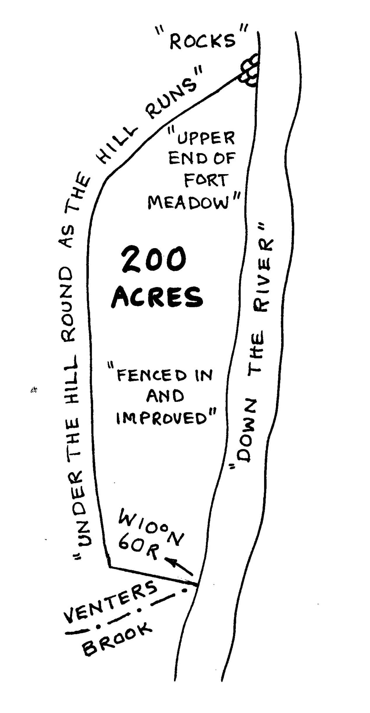 said Two hundred acres are bounded as follows, viz: Beginning at Venters Brook and runs West ten degrees North sixty rods to a Hill and then runs under the Hill round as the Hill runs to the rocks at the upper end of the Meadow called fort meadow, thence down the river to Venter Brook and that the same be and is incorporated into a Township by the name of Brattleborough, …
and that the Inhabitants that do or shall hereafter Inhabit said Township are hereby Declared to be Enfranchised with and entitled to all & every the priviledges & Immunities that other Towns within our said Province by law exercise and enjoy, and further that the said town as soon as there shall be fifty Familys resident and settled therein shall have the liberty of holding Two Fairs, one of which shall be held on the first Thursday in October annually, and the other on the first Thursday in February annually, which Fairs are not to continue & be held longer than the respective Saturday following the said respective Thursday, and as soon as said town shall consist of fifty familys a market shall be opened and kept one or more days in each week as may be tho`t most advantagious to the Inhabi-tants.
Also that the first meeting for the choice of Town Officers agreeable to the laws of our said Province shall be held on the fifteen Day of Jan` ry next which meeting shall be notifyed by Josiah Willard, Esq. who is hereby also appointed Moderator of the said first meeting which he is to notify and govern agreeable to the laws and customs of our said Province, and that the annual meeting forever hereafter for the choice of such officers of said Town shall be on the first Wednesday in March annually.
To have and to hold the said Tract of Land as above expressed together with all the Priviledges and appurtenances to them and their respective heirs & assigns forever, upon the following conditions Viz: That every Grantee, his heirs or assigns shall Plant or cultivate five acres of land within the term of five years for every fifty acres contained in his or their share or Proportion of Land in said Township, and continue to improve and settle the same by additional cultivations on Penalty of the Forfeiture of his Grant or share in said Township, & its reverting to his Majesty his heirs & successors to be by him or them regranted to such of his subjects as shall effectually settle & cultivate the same.
That all White or other Pine Trees within the said Township fit for Masting our Royal Navy be carefully Preserved for that use, and none to be cut or felled without his Majestys Especial Lycence for so doing first had and obtained upon the penalty of forfeiture of the right of such Grantee his heirs & assigns to us our heirs & successors as well as being subject to the Penalty of any act or acts of Parliament that now are or hereafter shall be enacted.
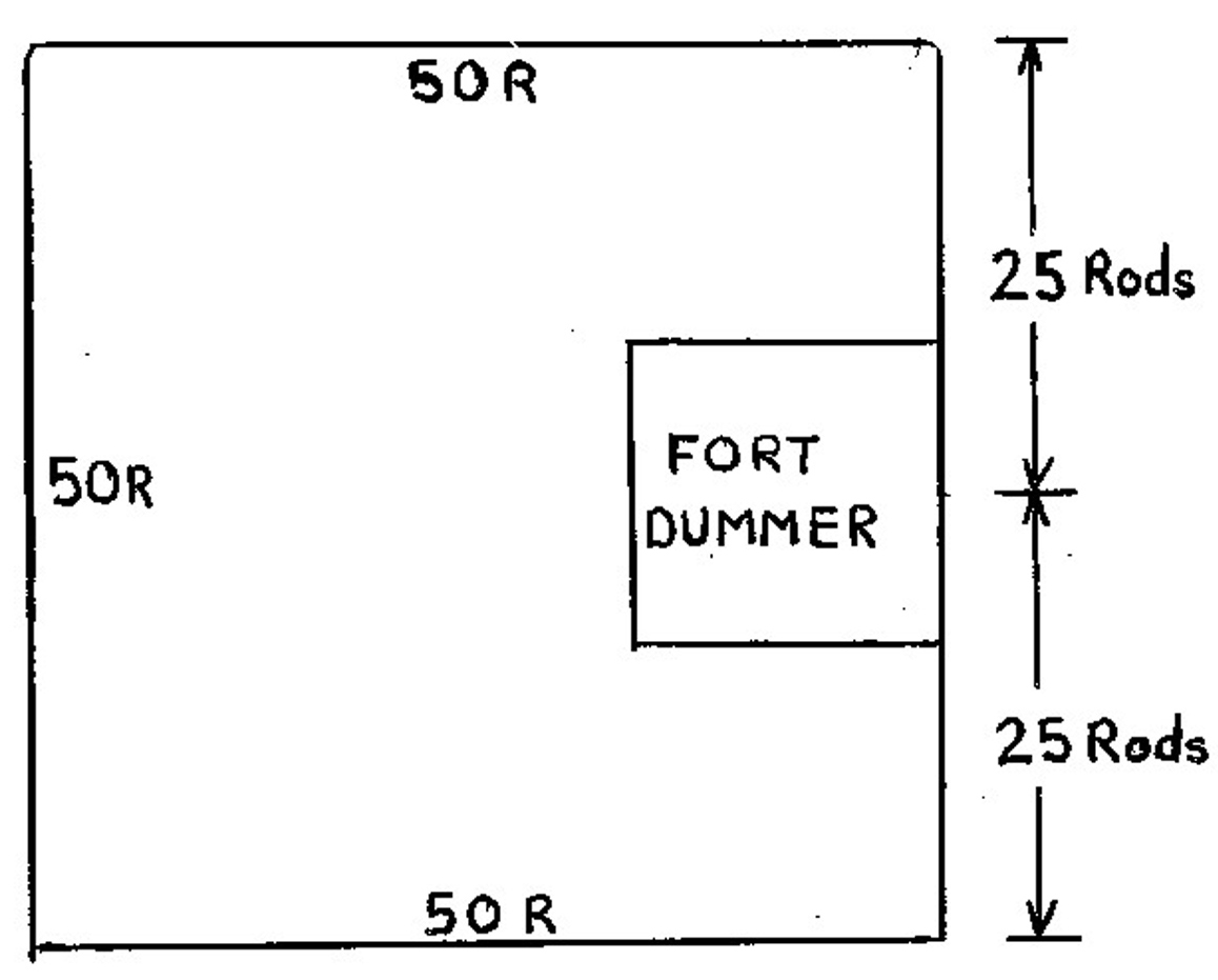 Also his fort Dummer & a Tract of land of fifty rods square round it, viz: fifty rods West, twenty-five rods South and twenty-five rods North of said Fort.
That before any Division of the land be made to and amongst the Grantees, a Tract of Land as near the center of the Township as the land will admit of shall be reserved and marked out for Town Lots, one of which shall be allotted to each Grantee of the contents of one acre yielding and paying therefor to us our heirs & successors for the space of ten years to be computed from the date hereof the rent of one Ear of Indian corn only on the first day of January annually if Lawfully Demanded, the first payment to be made on the first day of January after the first of January next ensuing the date hereof, and every Proprietor, Settler or Inhabitant shall yield and pay to us our heirs and successors yearly & every year forever from and after the expiration of the ten years, from the date hereof.
Namely on the first day of January which will be in the year of Our Lord Christ one thousand Seven Hundred & Sixty-four, one shilling Proclamation money for every hundred acres he so owns, settles or possesses, and so in proportion for a Greater or Lesser Tract of the said Land, which money shall be paid by the respective persons above said their heirs or assigns, in our Council Chamber in Portsmouth or to such officer or officers as shall be appointed to receive the same, and this to be in lieu of all other rents and services whatsoever in Testimony hereof we have caused the seal of our said Province to be hereunto affixed.
Witness Benning Wentworth, Esq., our Governor & Commander in Chief of our said Province the Twenty-six day of December in the year of our Lord Christ 1753 and in the Twenty-seventh year of our Reign.
B. WENTWORTH.
By his Excellencys command with advice of Council.
THEODORE ATKINSON,
Secty.
Entered and Recorded according to the original under the Province Seal, this 27th day of December 1753.
Pr THEODORE ATKINSON, Secty.
Names of the Grantees of Brattleborough, viz:
William Brattle, Jacob Wendell, James Read, Isaac Brodish, Owen Warland, William Lee, Ebenezer Smith, William Gammage, John Hicks, Ebenezer Bradish, James Whitemore, William Manning, Thomas Sherren, Thomas Hastings, Jonathan Sprague, John Warland, Benjamin Lynde, Andrew Oliver Junr., William Bowls, Cornelius Woodbury, William Willard, Oliver Willard, Samuel Allen, Moses Wright, Sampson French, Joseph French, William Fessenden, Stephen Palmer, Stephen Palmer Junr., William Barrett, Daniel Printice, Caleb Prentice, Ebenezer Stedman, Edward Marrett, Junr., Abner Hasey, Benjamin French, Thomas Blanchard, Thomas Blanchard, Junr, Jacob Fletcher, Samuel Searle, Samuel French, Sampson Willard, Oliver Coleburne, Jeremiah Coleburn, Peter Powers, Stephen Powers, Daniel Emerton, William Laurence, Abel Laurance, Mather Livermore.
Also by Theodore Atkinson, his Excellency Benning Wentworth, Esq – a Tract of Land to Contain Eight Hundred acres which is to be accounted Two of the within mentioned shares and Laid out and Bounded as within mentioned, one whole share for the Incorporated Society for the Propagation of the Gospel in foreign parts, one whole share for the first settled Minister of the Gospel in said Town, one whole share for a Glebe for the Ministry of the Church of England as by law Established. Also his Majestys Fort Dummer, and a Tract of Land Fifty rods round it, viz: 50 rods West, twenty-five rods South and twenty-five North of said Fort.
Recorded from the Back of the Charter for Brattleborough the 27th day of December, 1753.
Pr THEODORE ATKINSON, Secty.
12 Bibliography
Bibliography
Maps
The maps reprinted in this publication come from a variety of sources. To aid those who may be interested in further research into some of the non-published maps, we provide this partial cartobibliography. Maps listed here are manuscripts and maps which are not widely known. Other principal sources include the collections of the Vermont Archives ; Massachusetts Archives , the Vermont Historical Society; The New Hampshiore Archives; The Dartmouth College Library, the New York Archives, Library of Congress Geography & Map Division (LCG&M), and the National Archives. Where possible original maps have been reprinted. In some cases, due to unavailability of the original or legibility problems, copies have been substituted.
Map 1 The Brattleboro Area Douglass, William; Plan of the British Dominions in North America;
LCG&M; [this map was published in 1753 in London, but depicts conditions of a few years earlier.]
Map 3 Winchester Charter Map Blanchard, Joseph; [Winchester Charter Map]; Massachusetts Archives; Maps & Plans, Third
Series, Volume 35 Page 20;
Map 4 Mass / NH Province Line in 1741 Hazzen, Richard; Northern Boundary Line of the Province of Massachusetts Bay; New
Hampshire Archives; State Boundary Records
Map 5 Colonel Stoddards’ Design for Fort Dummer Stoddard, John; [January 30,1724 Letter]; Beinecke Rare Book & Manuscript Library, Yale
University; Dwight & Ferris Family Papers
Map 6 The Physiognomy of Fort Dummer Patten, Matthew; The Physiognomy of Fort Dummer; facsimile; Vermont Historic Society, Matt Jones Photostats
Map 9 Brattleboro Charter Map [na]; Brattleboro Town Charter; New Hampshire Archives; Town Charter Book Volume 1,
page 181
Map 10 Hinsdale Charter Map [na]; Hinsdale Town Charter; New Hampshire Archives; Town Charter Book Volume 1, page 178
Map 13 Towns in New York Province Dawes, William; [Towns in New York Province]; Massachusetts Archives; Maps & Plans;
Mass. Archives Vol 118, P. 466
Map 21 East Village in 1810 Elliott, Samuel; Letter to James Whitelaw; Surveyor-Generals Records; Vermont Archives
Map 23 Hinsdale Islands Map Hawkins, Daniel; Plat of the Town of Hinsdale; 1806; New Hampshire Town Plans; New
Hampshire Archives
Other Sources
Barry, Harold A. and others Before Our Time (1974)
Cabot, Mary Annals of the Town of Brattleboro (1924)
Child, Hamilton Windham County Gazeteer (1884)
Crocket, Walter Hill Vermont, The Green Mountain State (1921)
Hall, Benjamin History of Eastern Vermont (1857)
St. John, William Historical References to Brattleboro (1992); ms, binder; Brooks Memorial Library
Temple,J.H. & Sheldon, George History of the Town of Northfield (1875)
Dana, Lanice Paton A Local Chronology of Brattleboro, Vermont; With Interest; April, 1932
13 List of Maps
List of Maps
1. Introduction p. 5
Map 1 ca. 1745 New England’s Western Frontier Douglass, William; Plan of the British Dominions of New England in North America
2. Equivalent Lands and Fort Dummer p. 6
Map 2 1716 South Boundary of Equivalent Lands Cabot, Mary; Annals of Brattleboro
Map 3 1733 Winchester Charter Map Blanchard, Joseph; [Winchester Charter Map]; Massachusetts Archives
Map 4 1741 Mass / NH Boundary Line Hazzen, Richard; ms; New Hampshire Archives
Map 5 1724 Stoddard’s Design for Fort Dummer Stoddard, Col. John; ms; Beinecke Library
Map 6 1749 Reconstruction View of Fort Dummer Brasor, C.J. ; With Interest (magazine)
Map 7 1749 The Original 1749 Map of Fort Dummer Patten, Matthew; facsimile; Vermont Historical Society
Map 8 1749 The 1891 Tracing of Fort Dummer Patten, Matthew [1891 tracing]; Vermont Phoenix (newspaper)
3. The 1753 Charter and First Settlers p. 10
Map 9 1753 Brattleboro Charter Map n.a.; New Hampshire Archives
Map 10 1753 Hinsdale Charter Map n.a.; New Hampshire Archives
Map 11 1761 Southern Vermont 1757-1761 Blanchard & Langdon; An Accurate Map of His Majesty’s Province of New Hampshire
4. Early Land Divisions – The New York Period p. 12
Map 12 1766 New York Survey Colden, Alexander; ms; New York Archives
Map 13 ca. 1770 Towns in New York Province Dawes, William; ms; Massachusetts Archives
Map 14 1779 Brattleboro Area Sauthier, Claude Joseph; A Chorographical Map of the Province of New York
Map 15 1752-1788 Land Divisions 1752-1788 Wheeler,H.H.; from Annals of Brattleboro
Map 16 ca. 1774 Holland Map (portion) Holland, Samuel; A Topographical Map of the State of New Hampshire
Map 17 1774 Old Town Center Grout, Lewis; from Second Discourse on the Early History of the Congregational Church
5. Early Roads and Villlages p. 16
Map 18 1796 Brattleboro’s First Road map Whitelaw, James; A Correct Map of the State of Vermont
Map 19 1810 Brattleboro in 1810 Whitelaw, James; A Correct Map of the State of Vermont
Map 20 1821 Brattleboro in 1821 Whitelaw, James; A Correct Map of the State of Vermont
Map 21 1810 Brattleboro Village in 1810 Elliot, Samuel; ms; Vermont Archives
Map 22 1830 Proposed Canal Past Brattleboro Barnard,C.; Map No. 5, Connecticut River Canal, Experimental Line; National Archives
Map 23 1806 Bridge, Islands, Turnpike – Hinsdale Hawkins, Daniel; Plat of the Town of Hinsdale; New Hampshire Archives
Map 24 1858 Map of Cheshire County (portion) Fagan, L.; Map of Cheshire County, New Hampshire
Map 25 1877 Atlas of Cheshire County Map (portion) Rockwood, C.H.; Atlas of Cheshire County, New Hampshire
Map 26 1892 Atlas of the State of New Hampshire (portion) Hurd, D.H. ; Town and City Atlas of the State of New Hampshire
Map 27 1906 Map of Cheshire County (portion) Newell, Chauncey.; Map of Cheshire County, New Hampshire
Map 28 1849 Brattleboro & Vicinity Wesselhoeft, Robert; Second Report of the Brattleboro Hydropathic Establishment
6. Introduction to Land Ownership Maps & Bird’s Eye Views p. 22
7. Land Ownership Maps & Views – Downtown p. 24
Map 29 1852 Village of Brattleboro – Presdee & Edwards Presdee & Edwards; Map of the Village of Brattleboro
Map 30 1856 Plan of Brattleboro – McClellan Chace, J.; McClellans Map of Windham County, Vermont
Map 31 1856 Batchelder View of Brattleboro Batchelder, John; Brattleboro, Vt.
Map 32 1869 Centreville from Beers Atlas Beers & Co., F.W.; Atlas of Windham Co., Vermont
Map 33 1869 Plan of Brattleboro – Beers Atlas Beers & Co., F.W.; Atlas of Windham Co., Vermont
Map 34 1876 Brattleboro View by Bailey & Hazen Bailey, H.H.; & Hazen, J.C.; Brattleboro, Vt.
Map 35 1886 Brattleboro by Lucien Burleigh Burleigh, Lucien; Brattleboro, Vt.
Map 36 1895 Map of Brattleboro – D.L. Miller Miller, D.L.; Map of Brattleboro, Windham County, Vermont
8. Land Ownership Maps – West Brattleboro p. 50
Map 37 1856 West Brattleboro – McClellan Chace, J.; McClellans Map of Windham County, Vermont
Map 38 1869 West Brattleboro – Beers Beers & Co., F.W.; Atlas of Windham Co., Vermont
Map 39 1895 West Brattleboro – Miller Miller, D.L.; Map of Brattleboro, Windham County, Vermont
9. Land Ownership Maps – Entire Town p. 54
Map 40 1856 Town of Brattleboro – McClellan Chace, J.; McClellans Map of Windham County, Vermont
Map 41 ca. 1860 Town of Brattleboro – Grau Grau, C.W.; Brattleboro & Vicinity; Lith. by Fred. W. Boell,Jr. N.Y.
Map 42 1869 Town of Brattleboro – Beers Atlas Beers & Co.; Atlas of Windham Co., Vermont
Map 43 ca. 1880 Town of Brattleboro – Grau Grau, C.W.; Brattleboro & Vicinity; revised and reduced; Lith. by Hart & Von Arx, N.Y.
Map 44 1884 Town of Brattleboro – Child’s Gazetteer Childs, Hamilton; Windham County Gazeteer
Map 45 1895 Town of Brattleboro – Miller Miller, D.L.; Map of Brattleboro, Windham County, Vermont
Map 46 1895 Kipling’s Three Bridges Map Kipling, Rudyard; photograph; Dana Sprague Collection
Map 47 1893 Town of Brattleboro Topographic Map U.S. Geological Survey
10. Fire Insurance Maps – Main Street p. 66
Map 48 1885 Main Street Fire Insurance Map Sanborn Map Company; Brattleboro, Vermont; Library of Congress
Map 49 1912 Main Street Fire Insurance Map Sanborn Map Company; Brattleboro, Vermont; Brattleboro Historical Society
14 Modern Maps
Map 50
 On these two pages are modern maps drawn for this publication, based on the Brattleboro tax maps. The Town map shows the private property lots as dashed lines between the roads, while property lines are omitted from the downtown map to avoid clutter. These maps will be useful for study of historical land use as many of the present boundaries are the same as ancient property lines.
======================================================================================================================================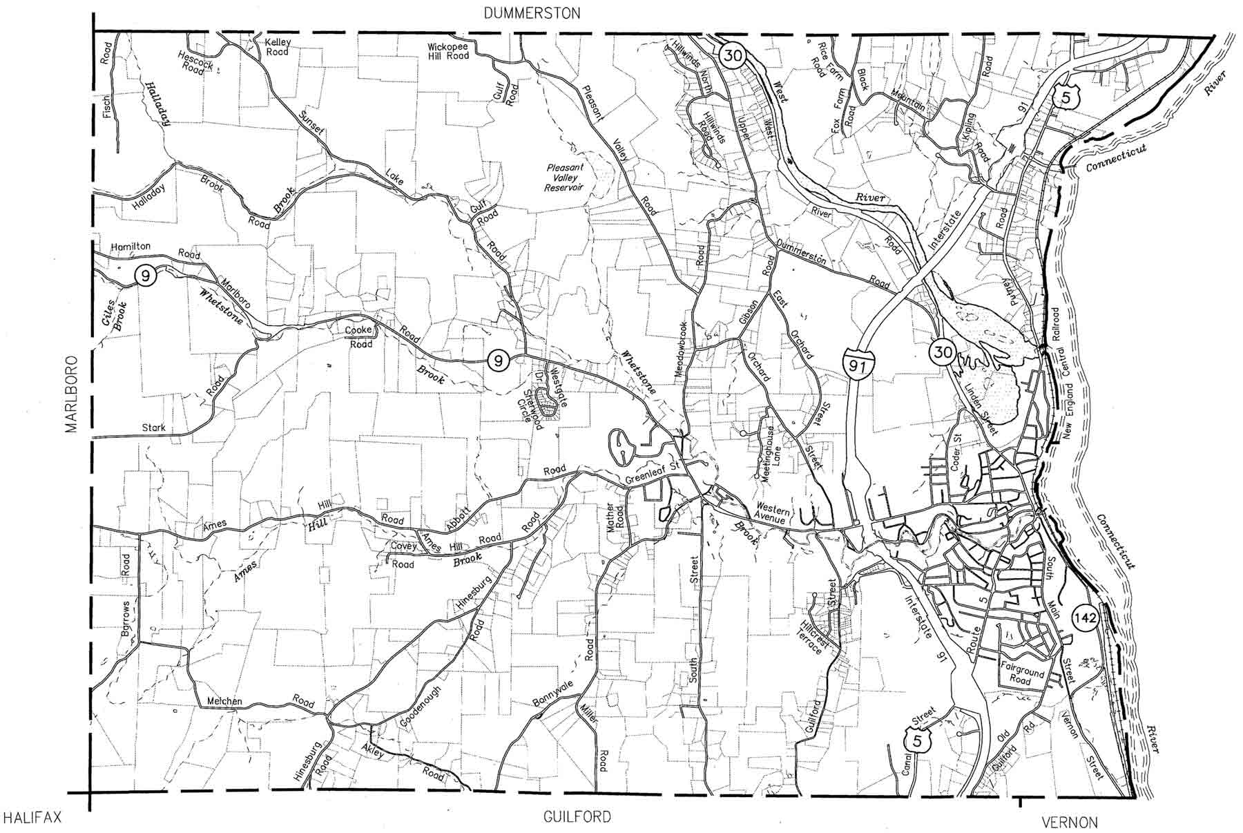 ======================================================================================================================================
It is especially interesting to note how the subdivison of the 5400 acre tract in southwest Brattleboro corresponds with many of these lines, and even with some of the streets. Barrows Road, Bonnyvale Road, South Street and Guilford Street Extension all seem to coincide in part with north-south lines on the old lotting plan (see pages 12 and 14). Many of the horizontal property lines appear to coincide with or be parallel with that old colonial grid. The north line of the 5400 acre tract, also referred to as the “center line” of the town in old documents, can be seen in fragments on this map. It passes through the top of Sherwood Circxle in the middle of the map, and just below the word “Orchard” on Orchard Street. The old town center on Meetinghouse Hill is the cluster of triangular shaped lots on Orchard Street. Note that the private lots to the north of this line are laid out in a more random, less orderly manner than those to the south.
15 Timeline & Population
Brattleboro Timeline from early 1700s to 1918
Summary of major events in local and national history to provide context for these maps.
1716 “Equivalent Lands” sold to raise funds for Yale College
1724 Fort Dummer built – 40 soldiers
1726 First English child born in Vermont, at Fort Dummer
1753 Brattleboro chartered as a town by New Hampshire
1760 Montreal captured by English – war threat ends in New England
1764 Brattleboro becomes part of New York province
1768 First Meetinghouse built on Orchard Street (Meetinghouse Hill)
1775-1783 Revolutionary War
1777-1791 Republic of Vermont
1784 New Meetinghouse built in West Brattleboro
1791 Vermont admitted to the United States – 14th State
1825 Erie Canal Built – improved commerce to midwest
1843 Dr. Wessselhoeft opens his Water Cure clinic in Brattleboro
1849 First Railroad comes to town
1854 Town Hall moved from West Brattleboro to Brattleboro
1861-1865 Civil War
1895 Trolley Line built in Brattleboro
1908 Model T Ford goes into production
1914-1918 World War I
======================================================================================================================================